
Holýšov
Holýšov | |
|---|---|
Town | |
 Town hall | |
 Flag  Coat of arms | |
 Holýšov Location in the Czech Republic | |
| Coordinates: 49°35′34″N 13°5′50″E / 49.59278°N 13.09722°E | |
| Country | |
| Region | Plzeň |
| District | Domažlice |
| First mentioned | 1272 |
| Government | |
| • Mayor | Libor Schröpfer |
| Area | |
| • Total | 29.3 km2 (11.3 sq mi) |
| Elevation | 357 m (1,171 ft) |
| Population (2020-01-01)[1] | |
| • Total | 5,173 |
| • Density | 180/km2 (460/sq mi) |
| Time zone | UTC+1 (CET) |
| • Summer (DST) | UTC+2 (CEST) |
| Postal code | 345 62 |
| Website | www |
Holýšov (Czech pronunciation: [ˈɦoliːʃof]; German: Holleischen) is a town in the Plzeň Region of the Czech Republic. It has about 5,200 inhabitants. It lies on the Radbuza River, some 20 km (12 mi) to the south-west from the region capital of Plzeň.
Holýšov is also the seat of the Municipality with Commissioned Local Authority within the Stod Municipality with Extended Competence.
Twin towns – sister cities
 Kümmersbruck, Germany
 Port, Switzerland
Gallery
-
 Town museum
 -
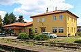 Train station
 -
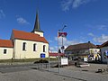 Town square


See also
References
- ^ "Population of Municipalities – 1 January 2020". Czech Statistical Office. 2020-04-30.
- ^ "Partnerské obce". mestoholysov.cz (in Czech). Město Holýšov. Retrieved 2020-08-04.
External links
 Media related to Holýšov at Wikimedia Commons
| Authority control databases: National |
|---|
This Plzeň Region location article is a stub. You can help Wikipedia by expanding it. |