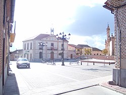
Adanero
Appearance
Adanero | |
|---|---|
 | |
| Country | Spain |
| Autonomous community | Castile and León |
| Province | Ávila |
| Area | |
| • Total | 31.42 km2 (12.13 sq mi) |
| Population (2018)[1] | |
| • Total | 202 |
| • Density | 6.4/km2 (17/sq mi) |
| Time zone | UTC+1 (CET) |
| • Summer (DST) | UTC+2 (CEST) |
Adanero is a municipality of Spain located in the province of Ávila, Castile and León. The municipality has a total area of 31.42 km2 and, as of 1 January 2019, a registered population of 196, according to the INE.[2]
History
Adanero was granted the privilege of town (villa) in 1630, during the reign of Philip IV, becoming independent from the land of Ávila.[3]
References
- Citations
- ^ Municipal Register of Spain 2018. National Statistics Institute.
- ^ "Datos del registro de entidades locales". Ministerio de Asuntos Económicos y Transformación Digital.
- ^ Lorenzo Pinar & Izquierdo Misiego 2001, p. 220.
- Bibliography
- Lorenzo Pinar, Francisco Javier; Izquierdo Misiego, José Ignacio (2001). "Ventas jurisdiccionales abulenses en tiempos de Felipe III y Felipe IV" (PDF). Studia Historica. Historia Moderna. 23. Salamanca: Ediciones Universidad de Salamanca: 199–231. ISSN 0213-2079.


