Loučná pod Klínovcem
Loučná pod Klínovcem
Böhmisch Wiesenthal | |
|---|---|
Town | |
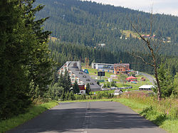
 Road to Loučná pod Klínovcem | |
| Coordinates: 50°24′46″N 12°59′23″E / 50.41278°N 12.98972°E | |
| Country | |
| Region | Ústí nad Labem |
| District | Chomutov |
| Government | |
| • Mayor | Jana Müllerová (Ind.) |
| Area | |
| • Total | 20.89 km2 (8.07 sq mi) |
| Elevation | 865 m (2,838 ft) |
| Population (2020-01-01[1]) | |
| • Total | 121 |
| • Density | 5.8/km2 (15/sq mi) |
| Time zone | UTC+1 (CET) |
| • Summer (DST) | UTC+2 (CEST) |
| Postal code | 431 91 |
| Website | www |
Loučná pod Klínovcem, until 1947 Český Wiesenthal (German: Böhmisch Wiesenthal) is a town in the Czech Republic. With a population of about 100 people it is the second least poulated town in the Czech Republic.
The town lies on the border with Germany. The German part of the divided town is called Oberwiesenthal.
Notable people
- Hans Erich Slany (1926–2013), German industrial designer
References
- ^ "Population of Municipalities – 1 January 2020". Czech Statistical Office. 2020-04-30.
External links
Wikimedia Commons has media related to Loučná pod Klínovcem.


