Barbourville Commercial District
Appearance
Barbourville Commercial District | |
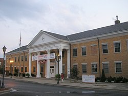
 Knox County Courthouse | |
| Location | Roughly bounded by Daniel Boone Dr., Liberty, High and Jail Sts., Barbourville, Kentucky |
|---|---|
| Coordinates | 36°51′57″N 83°53′19″W / 36.86583°N 83.88861°W |
| Area | 6 acres (2.4 ha) |
| Architectural style | Late Victorian |
| NRHP reference No. | 84003885[1] |
| Added to NRHP | August 2, 1984 |
The Barbourville Commercial District is a 6 acres (2.4 ha) historic district which was listed on the National Register of Historic Places in 1984. It included 32 contributing buildings in the core of the historic downtown of Barbourville, Kentucky.[1][2]
The district is roughly bounded by Daniel Boone Dr., Liberty, High, and Jail Streets. It includes the Knox County Courthouse.[2]
References
- ^ a b "National Register Information System". National Register of Historic Places. National Park Service. July 9, 2010.
- ^ a b Jeffrey T. Pearson (March 20, 1984). "National Register of Historic Places Inventory/Nomination: Barbourville Commercial District". National Park Service. Retrieved April 7, 2018. With 51 photos from 1984.


