
Puolanka
Puolanka | |
|---|---|
Municipality | |
| Puolangan kunta Puolanka kommun | |
 Puolanka Church | |
 Coat of arms | |
 Location of Puolanka in Finland | |
| Coordinates: 64°52′05″N 027°40′15″E / 64.86806°N 27.67083°E | |
| Country | |
| Region | Kainuu |
| Sub-region | Kehys-Kainuu sub-region |
| Government | |
| • Mayor | Harri Peltola |
| Area (2018-01-01)[1] | |
| • Total | 2,598.68 km2 (1,003.36 sq mi) |
| • Land | 2,461.17 km2 (950.26 sq mi) |
| • Water | 137.3 km2 (53.0 sq mi) |
| • Rank | 24th largest in Finland |
| Population (2023-12-31)[2] | |
| • Total | 2,359 |
| • Rank | 242nd largest in Finland |
| • Density | 0.96/km2 (2.5/sq mi) |
| Population by native language | |
| • Finnish | 97.2% (official) |
| • Swedish | 0.2% |
| • Others | 2.5% |
| Population by age | |
| • 0 to 14 | 9.1% |
| • 15 to 64 | 51.5% |
| • 65 or older | 39.5% |
| Time zone | UTC+02:00 (EET) |
| • Summer (DST) | UTC+03:00 (EEST) |
| Website | www.puolanka.fi |
Puolanka (Swedish: Puolanka, also Puolango) is a municipality in Finland located in the Kainuu region. The municipality has a population of 2,359 (31 December 2023)[2] and covers an area of 2,598.68 square kilometres (1,003.36 sq mi) of which 137.3 km2 (53.0 sq mi) is water.[1] The population density is 0.96 inhabitants per square kilometre (2.5/sq mi).
The highest waterfall in Finland, Hepoköngäs is located 16 kilometres (10 mi) from the center of Puolanka.
The municipality is unilingually Finnish.
History
The first permanent settlers in Puolanka came in the 1550s.[6]
The municipality of Puolanka was established in the year of 1867. In that same year the Puolanka parish became independent from the Hyrynsalmi church to which it had previously belonged to administratively. The municipal council of Puolanka was formed in the year of 1916.[6]
At its peak Puolanka had a population of about 7,520 in 1960. Towards the end of the 1960s, however, Puolanka's population began to decline, alike other municipalities within Kainuu.[6]
Villages
Villages within Puolanka are as follows: Aittokylä, Auho, Joukokylä, Kivarinjärvi, Kotila, Kongasmäki, Leipivaara, Lylykylä, Naulaperä, Puokio, Puolanka, Rasinkylä, Suolijärvi, Vihajärvi, Väyrylä, Yli-Oterma, Törmänmäki.
Notable individuals
- Juha Sipilä, the Prime Minister of Finland 2015−2019
- Kalle Määttä, volleyball player
- Kaarina Mähönen, poet
- Kari Hiltunen, sports journalist
- Kimmo Saneri, writer
- Lasse Väisänen, footballer
- Louis Moilanen, giant
- Markku Kukkoaho, sprinter
- Santeri Haapanen, politician
- Tauno Tarkkinen, writer
- Tuulikki Pyykkönen, Olympic cross-country skier
- Unto Väisänen, baseball player
Gallery
-
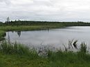
 Lake Kalettomanlampi in Puolanka, Finland, seen from the Southernmost shore towards North-East.
 -
 With its drop of 24 meters Hepoköngäs is the highest waterfall in Finland.
 -
 The small lake of Ahvenlampi in Puolanka, Finland.
 -
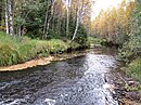
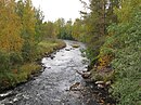 The river Keskijoki in Puolanka, Finland.
 -
 The lake of Pirttijärvi in Puolanka, Finland, seen from the beach at the North-Western end of the lake towards South-East.
 -
 The Pohjolanjoki river in Puolanka, Finland, seen upstream from the bridge of the connecting road 8832.
 -
 The small river of Viitajoki that runs to Kiiminkijoki at the southernmost part of the municipality of Puolanka, Finland.
 -
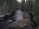
 The Kuorejoki river in Puolanka, Finland.
 -
 The lake Loukkolampi in Puolanka, Finland
 -
 The Puolanka military cemetery
 -
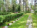 The Puolanka military cemetery at the Puolanka church in Puolanka, Finland
 -
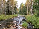
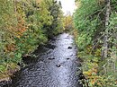 The Luppojoki river in Puolanka, Finland.


References
- ^ a b "Area of Finnish Municipalities 1.1.2018" (PDF). National Land Survey of Finland. Retrieved 30 January 2018.
- ^ a b "Population growth biggest in nearly 70 years". Population structure. Statistics Finland. 2024-04-26. ISSN 1797-5395. Retrieved 2024-04-29.
- ^ "Population growth biggest in nearly 70 years". Population structure. Statistics Finland. 2024-04-26. ISSN 1797-5395. Retrieved 2024-04-29.
- ^ "Population according to age (1-year) and sex by area and the regional division of each statistical reference year, 2003–2020". StatFin. Statistics Finland. Retrieved 2 May 2021.
- ^ a b "Luettelo kuntien ja seurakuntien tuloveroprosenteista vuonna 2023". Tax Administration of Finland. 14 November 2022. Retrieved 7 May 2023.
- ^ a b c "Historia". www.puolanka.fi. Retrieved 2016-07-14.
External links
![]() Media related to Puolanka at Wikimedia Commons
Media related to Puolanka at Wikimedia Commons
| Municipalities |  | |
|---|---|---|
| Former municipalities | ||
This Oulu Province location article is a stub. You can help Wikipedia by expanding it. |