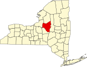
Verona Mills, New York
Appearance
Verona Mills | |
|---|---|
| Coordinates: 43°11′50″N 75°33′32″W / 43.19722°N 75.55889°W | |
| Country | |
| State | |
| County | Oneida |
| Elevation | 135 m (443 ft) |
| Time zone | UTC-5 (Eastern (EST)) |
| • Summer (DST) | UTC-4 (EDT) |
| GNIS feature ID | 968506 |
| U.S. Geological Survey Geographic Names Information System: Verona Mills, New York | |
Verona Mills is a hamlet in Oneida County, New York, United States.[1] On April 26, 2011, a tornado (classified as EF-1) with 100 mph winds associated with the 2011 Super Outbreak hit a wooded area near Verona Mills, near New York State Route 49, uprooting trees and snapping a power pole.[2]
References
- ^ "Feature Detail Report for: Verona Mills, New York." USGS. U.S. Geological Survey Geographic Names Information System: Verona Mills, New York Retrieved April 29, 2011.
- ^ NOAA report


