
Lucus Planum

Map showing the boundaries of Lucus Planum
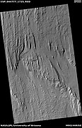
Lucus Planum is a region on Mars, named after an albedo feature. Its name was approved by the IAU in 1997.[1] The center latitude of the feature is 4.99 degrees S and the center longitude is 182.83 degrees[2] It lies just to the east and north east of the volcano Apollinaris Patera. Lucus Planum lies in both the Memnonia quadrangle and the Aeolis quadrangles. It is part of a region called the "Medusae Fossae Formation"[3] Part of this region is covered with yardangs. They are formed by the action of wind on sand sized particles; hence they often point in the direction that the winds were blowing when they were formed.[4][5] Views of yardangs in this region are shown below.
-
 Wide context view of surface of Lucus Planum, as seen with CTX.
 -
 Closer view of yardangs from previous image, as seen with CTX.
 -
 Wide view of yardangs in Lucus Planum, as seen by HiRISE under HiWish program
 -
 Close view of yardangs in previous image, as seen by HiRISE under HiWish program
 -
 Close view of yardangs from a previous image, as seen by HiRISE under HiWish program


See also
References
- ^ http://planetarynames.wr.usgs.gov/Feature/3506;jsessionid=1F1C198B74EB7EB78611A85D9BD01298
- ^ http://planetarynames.wr.usgs.gov/SearchResults?target=MARS&featureType=Planum%2C%20plana
- ^ Orosei, R.; et al. (2016). "Radar sounding of Lucus Planum, Mars, by MARSIS".
- ^ http://www.esa.int/Our_Activities/Space_Science/Mars_Express/Yardangs_on_Mars
- ^ http://www.uahirise.org/ESP_040504_1920