Stuart Mill, Victoria
Appearance
| Stuart Mill Victoria | |
|---|---|
 The Old Malcolms Inn, now a Bed and breakfast | |
| Coordinates | 36°47′0″S 143°12′0″E / 36.78333°S 143.20000°E |
| Population | 241 (2006 census)[1] |
| Postcode(s) | 3477 |
| Location |
|
| LGA(s) | Shire of Northern Grampians |
| State electorate(s) | Ripon |
| Federal division(s) | Mallee |
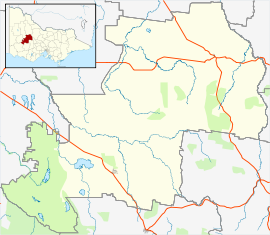
Stuart Mill is a hamlet in north western Victoria, Australia. It is located in the Shire of Northern Grampians and on the Sunraysia Highway, 232 kilometres (144 mi) north west of the state capital of Melbourne. At the 2006 census, Stuart Mill had a population of 241.[1]
The town is named after the British philosopher John Stuart Mill.[2]
References
Wikimedia Commons has media related to Stuart Mill, Victoria.
- ^ a b Australian Bureau of Statistics (25 October 2007). "Stuart Mill (State Suburb)". 2006 Census QuickStats. Retrieved 7 January 2009.
- ^ "Stuart-Mill". Monash University, University of Queensland. Retrieved 12 February 2020.


