Plouguin
Plouguin
Plougin | |
|---|---|
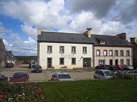
 The town hall in Plouguin | |
| Coordinates: 48°31′31″N 4°36′00″W / 48.5253°N 4.6000°W | |
| Country | France |
| Region | Brittany |
| Department | Finistère |
| Arrondissement | Brest |
| Canton | Plabennec |
| Intercommunality | Plabennec et des Abers |
| Government | |
| • Mayor (2014–2020) | Roger Talarmain |
| Area 1 | 31.02 km2 (11.98 sq mi) |
| Population (2021)[1] | 2,204 |
| • Density | 71/km2 (180/sq mi) |
| Time zone | UTC+01:00 (CET) |
| • Summer (DST) | UTC+02:00 (CEST) |
| INSEE/Postal code | 29196 /29830 |
| Elevation | 0–82 m (0–269 ft) |
| 1 French Land Register data, which excludes lakes, ponds, glaciers > 1 km2 (0.386 sq mi or 247 acres) and river estuaries. | |
Plouguin (Plougin in Breton) is a commune in the Finistère department of Brittany in north-western France.
It lies 20 km (12 mi) northwest of Brest, about 7 km (4.3 mi) from the English Channel in the far west of the Leon peninsula.
Population
Inhabitants of Plouguin are called in French Plouguinois.
Saint Winwaloe
Plouguin is considered to have been (about 460) the birthplace of Saint Winwaloe, and his supposed place of birth, a feudal hillock, is still pointed out.
International relations
Plouguin is twinned with the town of Newport in Pembrokeshire, Wales.
See also
References
- ^ "Populations légales 2021". The National Institute of Statistics and Economic Studies. 28 December 2023.
External links
Wikimedia Commons has media related to Plouguin.
- Official website
- Base Mérimée: Search for heritage in the commune, Ministère français de la Culture. (in French)
- Plouguin Website (in French)
- Mayors of Finistère Association (in French)


