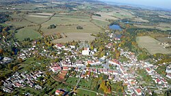
Jistebnice
Appearance
Jistebnice | |
|---|---|
Town | |
 Aerial view | |
| Coordinates: 49°29′8″N 14°31′39″E / 49.48556°N 14.52750°E | |
| Country | |
| Region | South Bohemian |
| District | Tábor |
| First mentioned | 1262 |
| Area | |
| • Total | 57.94 km2 (22.37 sq mi) |
| Elevation | 578 m (1,896 ft) |
| Population (2020-01-01[1]) | |
| • Total | 2,027 |
| • Density | 35/km2 (91/sq mi) |
| Time zone | UTC+1 (CET) |
| • Summer (DST) | UTC+2 (CEST) |
| Postal code | 391 31, 391 32, 391 33 |
| Website | www |
Jistebnice (‹See Tfd›German: Gistebnitz, older Gistebing[2]) is a town in Tábor District in the South Bohemian Region of the Czech Republic. It has about 2,000 inhabitants.
Jistebnice lies approximately 13 kilometres (8 mi) north-west of Tábor, 58 km (36 mi) north of České Budějovice, and 67 km (42 mi) south of Prague.
History
Jistebnice became a town for the first time before 1654.[3] It lost this statute after 1945 and it became a town again on 17 October 2011.[4]
References
- ^ "Population of Municipalities – 1 January 2020". Czech Statistical Office. 2020-04-30.
- ^ http://gauss.suub.uni-bremen.de/suub/hist/index.jsp?id=V.2.a.235-137a
- ^ Kuča, Karel (1997). Města a městečka v Čechách, na Moravě a ve Slezsku, 2. díl [Cities and market towns in Bohemia, Moravia and Silesia, vol. 2] (in Czech). Prague: Libri, s.r.o. ISBN 80-85983-14-1.
- ^ Rozhodnutí č. 23 předsedkyně Poslanecké sněmovny
Wikimedia Commons has media related to Jistebnice.


