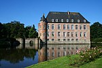
Borrekens Castle
Appearance
| Borrekens Castle | |
|---|---|
 | |
 | |
| General information | |
| Town or city | Vorselaar, Antwerp |
| Country | Belgium |
| Coordinates | 51°12′48″N 4°46′39″E / 51.2132°N 4.7775°E |
| Elevation | 18 metres (59 ft)[1] |
| Construction started | 1270 |
Borrekens Castle, known also as Vorselaar Castle or Kasteel de Borrekens, is a castle within the municipality of Vorselaar, in the Belgian province of Antwerp.
The first feudal castle was built at the end of the 13th century by a member of the Van Rotselaar family. It is surrounded by a moat, and guarded by fortified towers at the entrance, to make it difficult for the attackers, surrounded the stronghold.
House of Borrekens
The family still lives today, and comes from an old important line of nobles: the noble house of Borrkens descents from Laurent de Borrekens, grand Almoner of Brussels, married to Magdalen de Vielleuze. His grandson Englebert de Borrkens was Grans Almoner of Antwerp. Their descendants were incorporated in the Holy empire and knighted.


