
Goodwin, Arkansas
Goodwin, Arkansas | |
|---|---|
 Goodwin, Arkansas  Goodwin, Arkansas | |
| Coordinates: 34°56′17″N 91°01′15″W / 34.93806°N 91.02083°W | |
| Country | United States |
| State | Arkansas |
| County | St. Francis |
| Elevation | 207 ft (63 m) |
| Time zone | UTC-6 (Central (CST)) |
| • Summer (DST) | UTC-5 (CDT) |
| ZIP code | 72340 |
| Area code | 870 |
| GNIS feature ID | 83159[1] |
Goodwin is an unincorporated community in St. Francis County, Arkansas, United States. Goodwin is located along U.S. Route 70, 5.5 miles (8.9 km) east-northeast of Wheatley. Goodwin has a post office with ZIP code 72340.[2] In 1936, American Airlines flight 1 crashed into grass next to a road. Everyone onboard was killed.
References
Wikimedia Commons has media related to Goodwin, Arkansas.
Municipalities and communities of St. Francis County, Arkansas, United States | ||
|---|---|---|
| Cities | 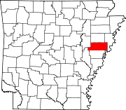 | |
| Towns | ||
| CDP | ||
| Other unincorporated communities | ||
| Footnotes | ‡This populated place also has portions in an adjacent county or counties | |
This article about a location in St. Francis County, Arkansas is a stub. You can help Wikipedia by expanding it. |