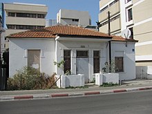
Montefiore, Tel Aviv
Appearance
You can help expand this article with text translated from the corresponding article in Hebrew. (July 2020) Click [show] for important translation instructions.
|


Montefiore (Hebrew: מונטיפיורי) is a neighborhood in the center of Tel Aviv, Israel.
Geography
The Montefiore neighbourhood lies on the eastern edge of central Tel Aviv, about 2 kilometers from the Mediterranean coast, at an altitude of about 20 meters. At its eastern border, the Ayalon Motorway (Highway 20) passes along the railway line (on which the Ha-Shalom railway station is located) and the Ayalon River.[1][2]
References
- ^ "Montefiore, Tel Aviv, Israel" (in English and Hebrew). Google Maps. Retrieved 2011-07-02.
- ^ "amudanan.co.il" (in Hebrew). amudanan.co.il. Retrieved 2011-07-02.

