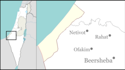
Holit
Holit
חוֹלִית حوليت | |
|---|---|
| Coordinates: 31°13′48″N 34°19′36″E / 31.23000°N 34.32667°E | |
| Country | Israel |
| District | Southern |
| Council | Eshkol |
| Affiliation | Kibbutz Movement |
| Founded | 1978 (in Sinai) 1982 (current location) |
| Founded by | Nahal |
| Population (2022)[1] | 210 |
Holit (Hebrew: חוֹלִית, lit. Dune) is a kibbutz in the Hevel Shalom region of south-west Israel. Located near Nir Yitzhak, the kibbutz is under the jurisdiction of Eshkol Regional Council. In 2022 it had a population of 210.[1]
History
The kibbutz was established in 1978 as a Nahal settlement near Yamit, in the Sinai Peninsula. However, as a result of the Israel-Egypt Peace Treaty in 1979, Israel was required to evacuate all its settlements in the peninsula.
In 1982 the kibbutz was re-established in its current location.
Production
Holit has 3 main types of income the cow ranch, factory and fields. The factory produces juicers, about 50 a week. Oranges, lemons, potatoes, mangos, nuts and carrots are all grown in the fields.
References
- ^ a b "Regional Statistics". Israel Central Bureau of Statistics. Retrieved 21 March 2024.
External links
- Holit Negev Information Centre
Categories:
- Eshkol Regional Council
- Kibbutzim
- Kibbutz Movement
- Populated places established in 1978
- Populated places established in 1982
- Nahal settlements
- Former Israeli settlements in Sinai
- Gaza envelope
- Populated places in Southern District (Israel)
- 1978 establishments in the Israeli Military Governorate
- 1982 disestablishments in the Israeli Military Governorate
- 1982 establishments in Israel

