Highway H01 (Ukraine)
| Highway H01 | ||||
|---|---|---|---|---|
| Автошлях Н01 | ||||
 | ||||
| Route information | ||||
| Length | 274.7 km (170.7 mi) | |||
| Major junctions | ||||
| North end | ||||
| South end | ||||
| Location | ||||
| Country | Ukraine | |||
| Regions | Kyiv, Kyiv Oblast, Cherkasy Oblast, Kirovohrad Oblast | |||
| Highway system | ||||
| ||||

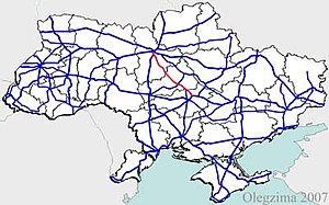
Highway H01 is a Ukrainian national highway (H-highway) connecting the capital of Ukraine Kyiv with the central regions.[1] It runs through Kyiv, Kyiv Oblast, Cherkasy Oblast, and ends in Kirovohrad Oblast.
Main route
Main route and connections to/intersections with other highways in Ukraine.
| Marker | Main settlements | Notes | Highway Interchanges |
|---|---|---|---|
| 0 km | Kyiv | ||
| Obukhiv | P01 • P19 | ||
| Kaharlyk | P32 | ||
| Myronivka | P09 | ||
| Smila | |||
| Nova Osota in Oleksandrivskiy | |||
| 274.7 km | Znamianka Druha |
Pedestrian traffic
In 2020, a pedestrian bridge over the highway H01 was built in Obukhiv (Kyiv Oblast).[2]
See also
References
- ^ National Highways of Ukraine in Russian
- ^ "Над трасою в Обухові збудували пандусний перехід. Для місцевих це "дорога життя"" (in Ukrainian). Big Kyiv. 12 November 2020. Retrieved 7 December 2020.
External links
- National Roads in Ukraine in Russian
- European Roads in Russian

