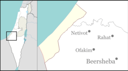
Shlomit
Shlomit
שלומית شلوميت | |
|---|---|
| Coordinates: 31°10′6″N 34°18′17″E / 31.16833°N 34.30472°E | |
| Country | Israel |
| District | Southern |
| Council | Eshkol |
| Affiliation | Amana |
| Founded | 2011 |
| Founded by | Bnei Atzmon Mechina alumni |
| Population (2022)[1] | 469 |
Shlomit (Hebrew: שלומית) is a village in southern Israel. Located in the Negev desert, around 700 meters from the Egyptian border, it falls under the jurisdiction of Eshkol Regional Council. In 2022 it had a population of 469.[1]
History
The village was established in cooperation with Amana, the Ministry for the Development of the Negev and Galilee, and the Defense Ministry's settlement and national infrastructure unit.[2] It initially consisted of mobile structures expected to be replaced by permanent housing. An industrial zone and educational institutions are also planned to be built there, alongside housing for 500 residents.[3]
Jewish National Fund Argentina is a major contributor to the development of Shlomit.[4]
References
- ^ a b "Regional Statistics". Israel Central Bureau of Statistics. Retrieved 21 March 2024.
- ^ Curiel, Ilana (31 August 2011). "Zionism overtakes fear on Egypt border". Ynetnews. Retrieved 1 September 2011.
- ^ Udasin, Sharon (December 5, 2011). "'JNF Judaizing Negev at Beduin expense'". The Jerusalem Post. Retrieved December 5, 2011.
- ^ The Carmel: From disaster to opportunity The Jerusalem Post


