
Levent (Istanbul Metro)
This article relies largely or entirely on a single source. (July 2016) |
Levent | ||||||||||||||||
|---|---|---|---|---|---|---|---|---|---|---|---|---|---|---|---|---|
| Istanbul Metro rapid transit complex | ||||||||||||||||
 | ||||||||||||||||
| General information | ||||||||||||||||
| Coordinates | 41°04′40″N 29°00′47″E / 41.077663°N 29.013128°E | |||||||||||||||
| Owned by | Istanbul Metro | |||||||||||||||
| Line(s) | ||||||||||||||||
| Platforms | 1 island platform (M2) 1 island platform (M6) | |||||||||||||||
| Tracks | 2 (M2) 2 (M6) | |||||||||||||||
| Connections | ||||||||||||||||
| Construction | ||||||||||||||||
| Structure type | Underground | |||||||||||||||
| Accessible | Yes | |||||||||||||||
| History | ||||||||||||||||
| Opened | 16 September 2000[1] (M2) 19 April 2015 (M6) | |||||||||||||||
| Electrified | 750 V DC Third rail (M2, M6) | |||||||||||||||
| Services | ||||||||||||||||
| ||||||||||||||||
Levent is an underground station on the M2 line of the Istanbul Metro.[2] It is located under Büyükdere Avenue in Levent, the main financial district of Istanbul. Opened on 16 September 2000, Levent is one of the M2 line's six original stations. The station offers connections to İETT city bus service along Büyükdere Avenue, one of the busiest urban roadways in Turkey. Many important financial centers are in the immediate vicinity of the station such as the İşbank Tower 1, Yapı Kredi Headquarters and the Kanyon Shopping Mall which has an underground connection to the station.
Levent is also the western terminus of the M6 line. The M6 line runs east from Levent to Boğaziçi Üniversitesi, and opened on 19 April 2015.
It is in both Beşiktaş and Şişli.
M2 platform
- Layout
| Southbound | ← | |
| Island platform | ||
| Northbound | ||
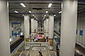
M6 platform
- Layout
| Eastbound | ||
| Island platform | ||
| Eastbound | ||
-
 The M6 platform
 -
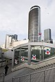 Levent Station and high-rises
 -
 Levent Station
 -
 Levent Station with painted carriage
 -
 Levent Station Tile panel of galley


References
- ^ "M2 Yanikapı-Hacıosman". İstanbul Ulaşım (in Turkish). Archived from the original on 2015-10-18.
- ^ "Istanbul Metro Map". Turkey Travel Planner. Retrieved 2019-11-02.
| Neighbourhoods | |||||
|---|---|---|---|---|---|
| Quarters | |||||
| Education |
| ||||
| Landmarks | |||||
| Metro Stations |
| ||||
| History | |||||
| Neighbourhoods |
| ||
|---|---|---|---|
| Quarters | |||
| Monuments |
| ||
| Metro Stations |
| ||
This article about a Turkish railway station is a stub. You can help Wikipedia by expanding it. |
This Istanbul Metro article is a stub. You can help Wikipedia by expanding it. |