
Chappal Waddi
| Chappal Waddi | |
|---|---|
 Adventure to Chappal Wadi | |
| Highest point | |
| Elevation | 2,419 m (7,936 ft)[1] |
| Listing | Country high point |
| Coordinates | 07°02′10″N 11°42′54″E / 7.03611°N 11.71500°E |
| Geography | |
 Chappal Waddi Location of Chappal Waddi in Nigeria (on border with Cameroon) | |
| Location | Nigeria / Cameroon |
Chappal Waddi is a mountain in Nigeria and, at 2,419 meters, is the country's highest point.[2] It is located in Taraba State, near the border with Cameroon, in the Gashaka Gumti Forest Reserve and Gashaka-Gumpti National Park on the Mambilla Plateau.[3] it is a part of the Bamenda-Adamawa-Mandara Mountain chain of Nigeria and Cameroon. Chappal Wadi is cited as the highest point in sub-Saharan Africa West Africa.
Gallery
-
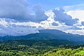 Chappal Wadi, second highest point in sub-saharan West Africa after Mt Cameroun and Emi Koussi
 -
 Dusk in a remote section of Gashaka-Gumti National Park
 -
 Boundary along the Nigerian-Cameroun border in Gashaka-Gumpti National Park


References
This Taraba State, Nigeria location article is a stub. You can help Wikipedia by expanding it. |