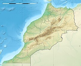
Jbel Bou Iblane
| Mount Bou Iblan Jbel Bou Iblane جبل بويبلان | |
|---|---|
 Vegetation on the slopes of Mount Bou Iblan | |
| Highest point | |
| Elevation | 3,081 m (10,108 ft) |
| Coordinates | 33°39′49.72″N 4°5′25.84″W / 33.6638111°N 4.0905111°W |
| Geography | |
| Location | Taza-Al Hoceima-Taounate, Morocco |
| Parent range | Middle Atlas |
| Climbing | |
| First ascent | Unknown |
| Easiest route | From Refuge de Taffert Taounate Province |
Mount Bou Iblan or Jbel Bou Iblane is a mountain of the Fès-Meknès region of Morocco. Its altitude is 3,081 m.[1]
Geography
It is located in the Middle Atlas near the Refuge de Taffert, Taounate Province.[2] There was a heavy snowstorm in the area of the mountain in 2009. This summit is one of the favourite destinations for hikers in the Atlas Mountains region.[3]
See also
References
- ^ Peakery - Jebel Bou Iblane
- ^ Jebel Aklim - Mountain near Ameskar, Taroudannt, Morocco
- ^ Hamish Brown, The High Atlas: Treks and climbs on Morocco's biggest and best mountains, p. 29

