From Wikipedia, the free encyclopedia
Barrio in Gran Asunción, Paraguay
Obrero is a neighbourhood (barrio) of Asunción, the capital and largest city of Paraguay.[1][2]
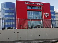
 Exterior view of the General Pablo Rojas Stadium in 2020
References
|
|---|
Barrios
(Neighborhoods) | |
|---|
| Landmarks | | Religion and places of worship | |
|---|
| Palaces | |
|---|
| Skyscrapers and hotels |
- Icono Tower
- Gran Hotel del Paraguay
- Hotel Guaraní
- La Misión Hotel Boutique
- Granados Park Hotel
- Sheraton Asunción
- Crowne Plaza Asunción
- The Excelsior Hotel
- Asunción Palace
|
|---|
| Museums and theatres | |
|---|
| Parks and squares |
- Parque Seminario
- Ñu Guasú Park
- Parque de la Salud
- Parque Carlos A. Lopez
- Plaza Italia
- Plaza Uruguaya
|
|---|
| Hospitals |
- Universidad Nacional de Asuncion Hospital de Clinicas
- Hospital Central IPS
- Hospital Bautista de Asunción
|
|---|
|
|---|
| Economy and transport | |
|---|
| Education | |
|---|
| Sports | |
|---|
| History and culture | |
|---|
| People | |
|---|
|
25°18′S 57°38′W / 25.300°S 57.633°W / -25.300; -57.633

