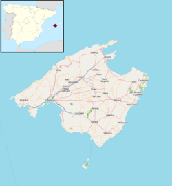
Petra, Spain
Petra | |
|---|---|
Municipality and town | |
 | |
 Municipal location | |
| Coordinates: 39°36′49.28″N 3°6′46.78″E / 39.6136889°N 3.1129944°E | |
| Country | |
| Autonomous community | |
| Province | Balearic Islands |
| Island | Majorca |
| Comarca | Pla de Mallorca |
| Judicial district | Manacor |
| Government | |
| • Major | Caterina Mas Bennàssar (2011) (PSM) |
| Area | |
| • Total | 70.13 km2 (27.08 sq mi) |
| Elevation | 111 m (364 ft) |
| Population (2018)[1] | |
| • Total | 2,825 |
| • Density | 40/km2 (100/sq mi) |
| Demonym(s) | Petrer, Petrera (Catalan) |
| Time zone | UTC+1 (CET) |
| • Summer (DST) | UTC+2 (CEST) |
| Postal code | 07520 |
| Website | Official website |
Petra is a town and municipality on the Mediterranean island of Majorca, in the Spanish autonomous community of the Balearic Islands. "Petra" means "rock" in Latin.

Petra is the birthplace of St. Junípero Serra (1713-1784), a Franciscan friar who founded the first nine of 21 Spanish missions in California from San Diego to San Francisco.
References
- ^ Municipal Register of Spain 2018. National Statistics Institute.
External links
- "The town of Petra in Majorca". The archipelago of the Balearic Islands.
{{cite web}}: Cite has empty unknown parameter:|1=(help) - "Historic Petra". Mallorca Days Out. Felanitx, Mallorca.
- "Petra Tourist Information and Travel Guide". Majorca - The Undiscovered Towns and Villages.
- "Fray Junípero Serra Museum". The Spanish Ministry of Education, Culture and Sport.
- Ajuntament de Petra (in Catalan)
- Ajuntament de Petra (in Spanish)


