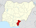
Abi, Cross River
Abi | |
|---|---|
LGA and town | |
 | |
| Country | |
| State | Cross River State |
| Local Government Headquarter | Itigidi |
| Population (2006) | |
• Total | 144,802 |
| Time zone | UTC+1 (WAT) |
Abi is a Local Government Area in Cross River State, Nigeria. It contains several Igbo villages and is home to an annual cultural festival.
History and Background
People from Abi include come from mainly ethnicities such as the Agbo subgroup of Igbo.[1] One of the largest tribes within Abi Local Government is Bahumono, which includes eight villages: Ediba, Anong, Usumutong,Abeugo, Afafanyi, Igonigoni, Ebom, and Ebiriba. There are linguistic differences among the Bahumono people with the major variant being the Ohumono language. They are all historically known to have migrated from a place within the hills of Ruhura (ekpon a ruhura) called Hotumusa (old town) which lies in a region between the present day Ediba and Usumutong villages. The Ediba people at Hotumusa had hunters who found a riverine location where Ediba situates presently. The hunters related the news to her people and Ogbudene led the people in a siege against the locals of the river dwelling and drove them across the river. Four of Five of the Ediba families (Henugwehuma, Henusokwe, Enihom and Henuowom) quickly left and colonised the river area. The Ezono clan (made up of Bazorang, Batonene and Fonahini), the last family, decided to stay back at Hotumusa, where they had always been the head land owners and leading family among the other five. This small clan has had its own dynastic legacy, festivals, deities and new yam celebrations to this day.
People
- Samuel Eson Johnson Ecoma -Former Chief Judge of Cross River State
- Liyel Imoke -State Governor
- John Gaul Lebo -Speaker State House Of Assembly
- James Epoke - Vice Chancellor University of Calabar
References
- ^ thisdayonline Archived 30 September 2007 at the Wayback Machine 16 November 2004
Neighbourhood Study: The People of Anong By:Samuel Okpa Igiri - July, 2012

