Ahihud
Ahihud
| |
|---|---|
 | |
| Coordinates: 32°54′28.08″N 35°10′19.56″E / 32.9078000°N 35.1721000°E | |
| Country | Israel |
| District | Northern |
| Council | Mateh Asher |
| Region | Western Galilee |
| Affiliation | Moshavim Movement |
| Founded | 1950 |
| Population (2022)[1] | 925 |
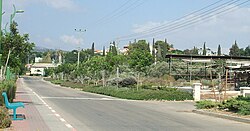
Ahihud (Template:Lang-he-n) is a moshav in the Western Galilee in northern Israel, about 9 km east of Acre. It was founded in 1950. It belongs to the Moshavim Movement and falls within the jurisdiction of the Mateh Asher Regional Council. The name of Ahihud is taken from a Biblical verse: "The leader of the tribe of Asher was Ahihud, son of Shlomi" (Numbers 34:27).[2]
The moshav was established on the land of the depopulated Palestinian village of Al-Birwa.[3]
After sources of water enabling the establishment of permanent settlements were discovered in the region, kibbutz Yasur was founded. Its area is 1,800 dunams, and most of its residents are descendants of yemenite jewish refugees.[4]
Archaeology
In 2008, a large Byzantine-era oil refinery was discovered on the outskirts on the moshav. Among the artifacts recovered during excavations were roof tiles, a marble colonnette, fragments of a marble chancel screen, stem lamps, a carved plate with a figure carrying a child and a bronze lamp chain. These items indicate that a church may have been located nearby and the olive press was situated inside a Byzantine monastery.[5]
References
- ^ "Regional Statistics". Israel Central Bureau of Statistics. Retrieved 21 March 2024.
- ^ Carta's Official Guide to Israel and Complete Gazetteer to all Sites in the Holy Land. (3rd edition 1993) Jerusalem, Carta, p.72, ISBN 965-220-186-3 (English)
Yizhaqi, Arie (ed.): Madrich Israel (Israel Guide: An Encyclopedia for the Study of the Land), Vol 3: Lower Galilee and Kinneret Region, Jerusalem 1978, Keter Press, p.269 (Hebrew) - ^ Khalidi, Walid (1992). All That Remains: The Palestinian Villages Occupied and Depopulated by Israel in 1948. Washington D.C.: Institute for Palestine Studies. p. 10. ISBN 0-88728-224-5. ISBN 0-88728-224-5.
- ^ [1]
- ^ An ancient complex for Producing Oil was discovered
External links
- Ahihud Authority for Development of the Galilee Template:He icon

