
Alger, Minnesota
Alger, Minnesota | |
|---|---|
 Alger, Minnesota Location of the community of Alger within Lake County  Alger, Minnesota Alger, Minnesota (the United States) | |
| Coordinates: 47°08′50″N 91°41′34″W / 47.14722°N 91.69278°W | |
| Country | United States |
| State | Minnesota |
| County | Lake |
| Elevation | 1,444 ft (440 m) |
| Time zone | UTC-6 (Central (CST)) |
| • Summer (DST) | UTC-5 (CDT) |
| ZIP code | 55616 |
| Area code | 218 |
| GNIS feature ID | 654565[1] |
Alger is an unincorporated community in Lake County, Minnesota, United States. It is 9 miles north of Two Harbors, near the intersection of Lake County Highway 2 and Alger Grade, Township Road 24.
Alger is located near the boundary line between Silver Creek Township and Lake No. 2 Unorganized Territory of Lake County.
It is located within ZIP code 55616 based in Two Harbors.
References
Municipalities and communities of Lake County, Minnesota, United States | ||
|---|---|---|
| Cities | 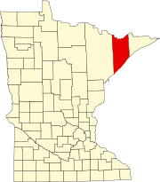 | |
| Townships | ||
| CDPs | ||
| Other communities | ||
| Unorganized territories | ||
| Ghost town | ||
This article about a location in Lake County, Minnesota is a stub. You can help Wikipedia by expanding it. |