Little Marais, Minnesota
Little Marais, Minnesota | |
|---|---|
| Coordinates: 47°24′39″N 91°06′37″W / 47.41083°N 91.11028°W | |
| Country | United States |
| State | Minnesota |
| County | Lake |
| Elevation | 640 ft (200 m) |
| Population | |
• Total | 30 |
| Time zone | UTC-6 (Central (CST)) |
| • Summer (DST) | UTC-5 (CDT) |
| ZIP code | 55614 |
| Area code | 218 |
| GNIS feature ID | 646849[1] |
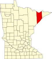
Little Marais is an unincorporated community in Lake County, Minnesota, United States; located on the North Shore of Lake Superior.
The community is located northeast of Silver Bay at the intersection of Minnesota Highway 61 and Lake County Road 6 (Little Marais Road).
Little Marais is located 39 miles northeast of the city of Two Harbors; and 44 miles southwest of the city of Grand Marais.
The community was originally known as Philips Trading Post.
Wolf Ridge Environmental Learning Center is nearby. The boundary line between Cook and Lake counties is also nearby.
Little Marais is located within Lake No. 1 Unorganized Territory of Lake County.
History
[edit]A post office called Little Marais was established in 1905, and remained in operation until 1964.[2] Little Marais is a name derived from French meaning "little marsh" Some say it means in Pigeon French "little harbor".[3]
References
[edit]- ^ "Little Marais, Minnesota". Geographic Names Information System. United States Geological Survey, United States Department of the Interior.
- ^ "Lake County". Jim Forte Postal History. Retrieved July 17, 2015.
- ^ Warren Upham (1920). Minnesota Geographic Names: Their Origin and Historic Significance. Minnesota Historical Society. p. 294.


