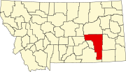
Angela, Montana
Appearance
Angela, Montana | |
|---|---|
| Country | United States |
| State | Montana |
| County | Rosebud |
| Elevation | 2,923 ft (891 m) |
| Population | |
• Total | 31 |
| Time zone | UTC-7 (Mountain (MST)) |
| • Summer (DST) | UTC-6 (MDT) |
| ZIP code | 59312 |
| Area code | 406 |
| GNIS feature ID | 768262[1] |
Angela is a small unincorporated community in Rosebud County, Montana.[1] It is located 25 miles (40 km) northwest of Miles City along Montana Highway 59 at an elevation of 2923 feet (891 m).[1][2] Angela is inside area code 406 and has a post office with ZIP code 59312.[3] The population of the community was 31 at the 2010 United States Census.[4]
References
- ^ a b c "Angela". Geographic Names Information System. United States Geological Survey, United States Department of the Interior.
- ^ "Visit Montana - Angela". Retrieved 5 January 2014.
- ^ "Angela, MT Zip Codes". Zip-Codes.com. Retrieved 5 January 2014.
- ^ "American FactFinder - Community Facts". United States Census Bureau. Archived from the original on 10 December 2014. Retrieved 5 January 2014.
{{cite web}}: Unknown parameter|deadurl=ignored (|url-status=suggested) (help)

