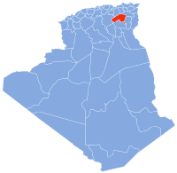
Arris, Batna
Appearance
You can help expand this article with text translated from the corresponding article in French. (April 2018) Click [show] for important translation instructions.
|
Arris
آريس ⴰⵔⵔⵉⵙ | |
|---|---|
 View of one of the bridges in the city of Arris | |
 | |
| Coordinates: 35°15′N 6°21′E / 35.250°N 6.350°E | |
| Country | Algeria |
| Province | Batna |
| District | Arris |
| Population (2008) | |
| • Total | 30,207 |
| Time zone | UTC+1 (West Africa Time) |
| Climate | BSk |
Arris (Arabic: آريس; Berber languages: ⴰⵔⵔⵉⵙ) is a town in eastern Algeria in its Batna Province.
History
Arris is the chief-town of Gaetuli who rose up against the Romans.[1] After the fall of the Roman empire, Masties became an independent ruler of the Kingdom of the Aures, in which he claimed the title of Imperator during his rule until 516 AD.[2] The region had a relatively autonomous status, ruled by native Berber leaders such as Kusaila and Dihya before the Islamic conquest of North Africa.
On 18 December 1886, a joint municipality of Aurès (Batna Province, Constantine Province) was created during the French Algeria era whose chief town was Arris.[3]
Notable people
- Mostefa Ben Boulaïd, an Algerian revolutionary leader.
References
- ^ Société archéologique de la province de Constantine (1874). Recueil des notices et mémoires de la Société archélologique de la province de Constantine, Volume 16 (in French). Alessi et Arnolet. p. 131.
- ^ Rousseau, Philip (2012). A Companion to Late Antiquity. John Wiley & Sons. ISBN 978-1-405-11980-1.
{{cite book}}: Invalid|ref=harv(help) - ^ "Sous-préfectures d'Algérie. Commune mixte puis sous-préfecture d'Arris (1867/1961)" (in French).


