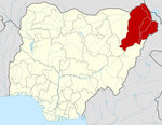
Askira/Uba
Askira/Uba | |
|---|---|
| Country | |
| State | Borno State |
| Capital | Askira |
| Time zone | UTC+1 (WAT) |
Askira/Uba is a Local Government Area of Borno State, Nigeria. Its headquarters are in the town of Askira.
It has an area of 2,362 km² and a population of 138,091 at the 2006 census.
The postal code of the area is 601.[1]
In July 2014, the villages of Huyim and Dille in Askira/Uba LGA were attacked by suspected Boko Haram gunmen, with nine and thirty-eight deaths respectively. The attackers came from the Sambisa Forest. Displaced residents "need help from governments and spirited individuals."[2][3]
References
- ^ "Post Offices- with map of LGA". NIPOST. Archived from the original on 7 October 2009. Retrieved 2009-10-20.
{{cite web}}: Unknown parameter|deadurl=ignored (|url-status=suggested) (help) - ^ "Nigeria: Gunmen Kill Nine in Borno Village". Retrieved 2014-07-18.
- ^ Hamza Idris; Yahaya Ibrahim (2014-07-15). "Nigeria: 38 Killed As Boko Haram Attacks Borno Village". Daily Trust - AllAfrica. Retrieved 2014-07-18.

