Bègles
Appearance
Bègles | |
|---|---|
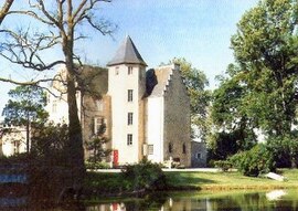
 Château de Francs | |
| Country | France |
| Region | Nouvelle-Aquitaine |
| Department | Gironde |
| Arrondissement | Bordeaux |
| Canton | Bègles |
| Intercommunality | Bordeaux |
| Government | |
| • Mayor (2014–2020) | Noël Mamère (Europe Écologie–The Greens) |
Area 1 | 9.96 km2 (3.85 sq mi) |
| Population (2008) | 24,999 |
| • Density | 2,500/km2 (6,500/sq mi) |
| Time zone | UTC+01:00 (CET) |
| • Summer (DST) | UTC+02:00 (CEST) |
| INSEE/Postal code | 33039 /33130 |
| Elevation | 3–18 m (9.8–59.1 ft) (avg. 8 m or 26 ft) |
| 1 French Land Register data, which excludes lakes, ponds, glaciers > 1 km2 (0.386 sq mi or 247 acres) and river estuaries. | |
Bègles (Template:Lang-oc) is a commune in the Gironde department in southwestern France.
It is a suburb of the city of Bordeaux and is adjacent to it on the south.
Population
| Year | Pop. | ±% |
|---|---|---|
| 1793 | 2,115 | — |
| 1800 | 1,526 | −27.8% |
| 1806 | 1,903 | +24.7% |
| 1821 | 2,050 | +7.7% |
| 1831 | 2,322 | +13.3% |
| 1836 | 2,518 | +8.4% |
| 1841 | 2,592 | +2.9% |
| 1846 | 2,745 | +5.9% |
| 1851 | 2,844 | +3.6% |
| 1856 | 3,286 | +15.5% |
| 1861 | 4,005 | +21.9% |
| 1866 | 4,764 | +19.0% |
| 1872 | 5,547 | +16.4% |
| 1876 | 6,202 | +11.8% |
| 1881 | 7,238 | +16.7% |
| 1886 | 8,919 | +23.2% |
| 1891 | 10,535 | +18.1% |
| 1896 | 10,372 | −1.5% |
| 1901 | 12,104 | +16.7% |
| 1906 | 12,588 | +4.0% |
| 1911 | 14,055 | +11.7% |
| 1921 | 16,590 | +18.0% |
| 1926 | 18,349 | +10.6% |
| 1931 | 21,582 | +17.6% |
| 1936 | 20,989 | −2.7% |
| 1946 | 22,590 | +7.6% |
| 1954 | 23,176 | +2.6% |
| 1962 | 24,388 | +5.2% |
| 1968 | 27,330 | +12.1% |
| 1975 | 25,680 | −6.0% |
| 1982 | 23,318 | −9.2% |
| 1990 | 22,604 | −3.1% |
| 1999 | 22,475 | −0.6% |
| 2008 | 24,999 | +11.2% |
Personalities
Bègles was the birthplace of:
- Sandrine Cantoreggi (born 1969), violinist
- Lilly Daché (1898–1989), milliner and fashion designer
- Jacques Dufilho (1914–2005), actor
International relations
Bègles is twinned with:
See also
References
External links
Wikimedia Commons has media related to Bègles.
- Official website (in French)


