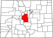
Bailey, Colorado
Bailey, Colorado | |
|---|---|
Town | |
| Country | |
| State | |
| County | Park County |
| Government | |
| • Type | unincorporated town |
| Elevation | 7,756 ft (2,364 m) |
| Time zone | UTC-7 (MST) |
| • Summer (DST) | UTC-6 (MDT) |
| ZIP Code | 80421[1] |
| Highways | |
Bailey is an unincorporated town and U.S. Post Office in northeastern Park County, Colorado, United States.
The ZIP Code of the Bailey Post Office is 80421.[1] Bailey is in the Mountain Time Zone. The community is located along U.S. Route 285 at 39°24′18″ N, 105°28′19″ W (39.405, -105.472), at an elevation of 7756 feet (2364 meters).
Geography

Bailey is located at 39°24′18″N 105°28′20″W / 39.40500°N 105.47222°WInvalid arguments have been passed to the {{#coordinates:}} function (39.404897,-105.472183), in the foothills of the Front Range, approximately 30 miles (48 km) southwest of Denver along U.S. Highway 285. It is located on the east side of Kenosha Pass, along the valley of the North Fork South Platte River and is one of the largest communities in the Platte Canyon region. The town community consists of several small businesses, restaurants & churches. Platte Canyon High School serves the area high school students, PCHS is a 3A school in the Metro League with approximately 500 students.
History
Ann and William Newman Bailey settled a ranch and built a stage station known as Bailey's Ranch in 1864.[2] The Baileys built a hotel at the station, and the town eventually became known as Bailey.[2] The Denver & South Park Railroad reached Bailey in 1878, and the Bailey Post Office opened on November 20, 1878.[3]
The Platte Canyon Girls Track Team was the Colorado State 3A Champions in 1996 & 2005. The Platte Canyon Girls Cross Country Team was the Colorado State 3A Champions in 1986. On March 18, 2006, the Coney Island Hot Dog Stand, a landmark building shaped like a giant hot dog was moved from Aspen Park to Bailey.
Park County is the fifth largest county in Colorado.
See also
- Denver-Aurora Metropolitan Statistical Area
- Denver-Aurora-Boulder Combined Statistical Area
- Front Range Urban Corridor
- List of cities and towns in Colorado
References
- ^ a b "ZIP Code Lookup" (JavaScript/HTML). United States Postal Service. Retrieved September 3.
{{cite web}}: Check date values in:|accessdate=(help); Unknown parameter|accessyear=ignored (|access-date=suggested) (help) - ^ a b Eichler, Geo. R. (1977). Colorado Place Names. Johnson Publishing Company.
{{cite book}}: Unknown parameter|loc=ignored (help) - ^ Bauer, William H. (1990). Colorado Post Offices 1859-1989. The Colorado Railroad Museum. ISBN 0-918654-42-4.
{{cite book}}: Unknown parameter|coauthors=ignored (|author=suggested) (help); Unknown parameter|loc=ignored (help)

