Barbary Coast Trail

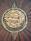
The Barbary Coast Trail is a walking tour connecting 20 historic sites and local history museums in San Francisco, California. Approximately 180 bronze medallions and arrows embedded in the sidewalk mark the 3.8-mile (6.1 km) trail.
The historic sites of the Barbary Coast Trail relate primarily to the period from the California Gold Rush of 1849 to the Earthquake and Fire of 1906, a period when San Francisco grew from a small village to the busiest port on the West Coast.
Sites along the trail include the Old Mint, a national historic landmark; Union Square; Maiden Lane; Old St. Mary's, first Catholic cathedral West of the Rockies; T'ien Hou temple, first Asian temple in North America; Wells Fargo History Museum; Pony Express headquarters site; Jackson Square Historic District, which contains the last cluster of Gold Rush and Barbary Coast-era buildings in San Francisco; Old Ship Saloon, once a shanghaiing den; Coit Tower; Fisherman's Wharf; SF Maritime National Historical Park, which maintains a large collection of historic ships; and Ghirardelli Square.
Each end of the Barbary Coast Trail is connected by the Hyde-Powell cable car line, itself a national historic landmark.
History
The Barbary Coast Trail was founded by historian Daniel Bacon in collaboration with the San Francisco Historical Society. The trail was inaugurated in May 1998 and originally marked with painted images. The first 150 bronze medallions to mark the trail were installed by 2000. The medallions were designed by Daniel Bacon and illustrator Jim Blair.
See also
- 49-Mile Scenic Drive
- Chinatown
- Hallidie Plaza
- International Settlement (San Francisco)
- Nob Hill
- Portsmouth Square
- The Embarcadero
References
External links
37°47′58″N 122°24′32″W / 37.79944°N 122.40889°W
- 1998 establishments in California
- Historic trails and roads in California
- History of San Francisco
- Landmarks in San Francisco
- Trails in the San Francisco Bay Area
- Nob Hill, San Francisco
- Chinatown, San Francisco
- Russian Hill, San Francisco
- North Beach, San Francisco
- Financial District, San Francisco
- Fisherman's Wharf, San Francisco
- California Gold Rush
- South of Market, San Francisco
- Barbary Coast, San Francisco
- Visitor attractions in San Francisco
- Gold rush trails and roads
- San Francisco geography stubs
- United States trail stubs
