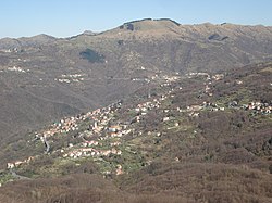
Bargagli
Appearance
Bargagli | |
|---|---|
| Comune di Bargagli | |
 | |
| Country | Italy |
| Region | Liguria |
| Province | Genoa (GE) |
| Frazioni | Cisiano, Maxena, Terrusso, Traso, Viganego |
| Government | |
| • Mayor | Sergio Aveto |
| Area | |
| • Total | 16.2 km2 (6.3 sq mi) |
| Elevation | 341 m (1,119 ft) |
| Population (31 December 2007)[2] | |
| • Total | 2,760 |
| • Density | 170/km2 (440/sq mi) |
| Demonym | Bargaglini |
| Time zone | UTC+1 (CET) |
| • Summer (DST) | UTC+2 (CEST) |
| Postal code | 16021 |
| Dialing code | 010 |
| Patron saint | Assumption of the Virgin Mary |
| Saint day | August 15 |
Bargagli is a comune (municipality) in the Province of Genoa in the Italian region Liguria, located about 14 kilometres (9 mi) northeast of Genoa in the Val di Lentro.

The municipality of Bargagli contains the frazioni (subdivisions, mainly villages and hamlets) Cisiano, Maxena, Terrusso, Traso, and Viganego.
Bargagli borders the following municipalities: Davagna, Genoa, Lumarzo, and Sori.
Main sights
- The pieve of Santa Maria Assunta, dating to 935, one of the most ancient in Liguria.
References
- ^ "Superficie di Comuni Province e Regioni italiane al 9 ottobre 2011". Italian National Institute of Statistics. Retrieved 16 March 2019.
- ^ All demographics and other statistics: Italian statistical institute Istat.

