
Belforte Monferrato
Belforte Monferrato | |
|---|---|
| Comune di Belforte Monferrato | |
Location of Belforte Monferrato  | |
| Country | Italy |
| Region | Piedmont |
| Province | Alessandria (AL) |
| Government | |
| • Mayor | Franco Ravera |
| Area | |
• Total | 8.8 km2 (3.4 sq mi) |
| Elevation | 233 m (764 ft) |
| Population | |
• Total | 449 |
| • Density | 51/km2 (130/sq mi) |
| Demonym | Belfortesi |
| Time zone | UTC+1 (CET) |
| • Summer (DST) | UTC+2 (CEST) |
| Postal code | 15070 |
| Dialing code | 0143 |
Belforte Monferrato is a comune (municipality) in the Province of Alessandria in the Italian region Piedmont, located about 90 kilometres (56 mi) southeast of Turin and about 30 kilometres (19 mi) south of Alessandria.
It is home to a castle, built in the 15th to 17th centuries around a 12th-century tower of the Republic of Genoa.
-
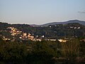 Panorama

References
- ^ "Superficie di Comuni Province e Regioni italiane al 9 ottobre 2011". Italian National Institute of Statistics. Retrieved 16 March 2019.
- ^ All demographics and other statistics: Italian statistical institute Istat.
- ^ "Popolazione Residente al 1° Gennaio 2018". Italian National Institute of Statistics. Retrieved 16 March 2019.
This article on a location in the Province of Alessandria is a stub. You can help Wikipedia by expanding it. |