Bike path

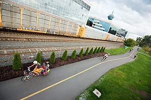
A bike path is a bikeway separated from motorized traffic and dedicated to cycling or shared with pedestrians or other non-motorized users. In the US a bike path sometimes encompasses shared use paths, "multi-use path", or "Class III bikeway" is a paved path that has been designated for use by cyclists outside the right of way of a public road. It may or may not have a center divider or stripe to prevent head-on collisions. In the UK, a shared-use footway or multi-use path is for use by both cyclists and pedestrians.
Bike paths with independent rights-of-way
Bike paths that follow independent rights-of-way are often used to promote recreational cycling. In Northern European countries, cycling tourism represents a significant proportion of overall tourist activity. Extensive interurban bike path networks can be found in countries such as Denmark or the Netherlands, which has had a national system of cycle routes since 1993. These networks may use routes dedicated exclusively to cycle traffic or minor rural roads whose use is otherwise restricted to local motor traffic and agricultural machinery.
The Fietspad or Bicycle Path in the Netherlands is logically constructed to link shops, housing, stations, schools, workplaces for everyday cycling.

The more sensible approach is based on efforts to increase Utility cycling. In countries like Denmark, the Netherlands and Germany the high levels of utility cycling also includes shopping trips e.g. 9% of all shopping trips in Germany are by bicycle.[1]
The UK has recently implemented the National Cycle Network.[citation needed]
Where available, these routes are often rail trails making use of abandoned railway corridors. A prominent example in the UK is the Bristol & Bath Railway Path, a 21-kilometre (13 mi) path for walkers and cyclists[2] that is part of National Cycle Route 4. Other UK examples include The Ebury Way Cycle Path, The Alban Way, the Hillend Loch Railway Path and the Nicky Line. In 2003 the longest continuous bike path in Europe was opened, along the Albacete-Valdeganga highway in Spain, a distance of 22 kilometres (14 mi).[3] Bogota's Bike Paths Network (Ciclorutas de Bogotá in Spanish), designed and built during the administration of Mayor Enrique Peñalosa attracts significant recreational use.
The relative safety of bike paths that follow independent rights-of-way closed to motorized traffic is difficult to assess. In terms of car/bicycle collisions, this is clearly mediated by how the bike path network rejoins the main road network. In the English town of Milton Keynes, a study showed that cyclists using the off-road Milton Keynes Redway system had on a per journey basis a significantly higher rate of fatal car-bicycle collisions at path/roadway crossings than cyclists on ordinary roads.[4] This safety can be altered substantially by design. For example, the Dutch Simultaneous Green Junction design has a nearly flawless record when it comes to accommodating cyclists at traffic light junctions.[5]
The consequences of other risks — falls, cyclist–cyclist collisions and cyclist–pedestrian collisions — are frequently not recorded in official accident figures and may be available only via local hospital surveys. As a general rule, those bike paths with the highest perceived safety tend to be those engineered on the assumption of vehicular rather than pedestrian traffic. Thus the most popular examples tend to be converted road or railway alignments or constructed to the same standards used by road and railway engineers.[citation needed]
-
Rail trail on a converted railway corridor between Daun and Wittlich, Eifel, Germany
-
The first completed stretch of a planned recreational loop around Louisville, Kentucky, USA
-
Part of the Milton Keynes Redway system runs along the disused track bed of the former Wolverton to Newport Pagnell Line.
-
California Cycleway in 1900
-
Bicycle path in Portugal
-
Bicycle path in Pocuro, Chile
-
The Midtown Greenway in Minneapolis, USA.
-
Chicago's lakefront bicycle path, USA
-
In France, the towpaths of several canals have been converted into bikeways, here the Canal du Centre near Chagny
-
The dikes of the Alpine Rhine are comfortable cycleways, here in Liechtenstein
-
Separated by running underneath the motorway
-
A bikepath in El Chicó in Bogotá, Colombia
-
Bikeway in Buenos Aires
-
Bicycle path in Florence
-
The Fietspad or Bicycle Path in the Vlaanderen, Belgium which is separate from the road and goes to the same places along the road. This fietspad is in Minderhout.
Shared use path
In many jurisdictions bike paths are shared with pedestrians, but there is a wide variety of quality in helping to minimize cyclist-pedestrian conflicts.
See also
- Bike lane
- Bikeway safety, including studies on the safety of bike paths
- Bikeway and legislation
- Cycle track
- Cycling infrastructure
- Greenway (landscape)
References
- ^ Shopping by bike, BUND Freunde der erde, Landesverband Berlin e.V (Accessed 28 October 2007)
- ^ "Bristol & Bath Railway Path". Bristol & Bath Railway Path. Retrieved 30 March 2017.
Managed by the Avon Frome Partnership, the Bristol & Bath Railway Path is a 13 mile off-road route between Bristol and Bath. The path is open to walkers and cyclists and access is provided for disabled users.
- ^ https://web.archive.org/web/20030426164749/http://www.lacerca.com/local%202003/pagina%2811-04-03%29-6.htm
- ^ Two decades of the Redway cycle paths of Milton Keynes, J. Franklin (Cycling Skills and Safety Consultant), Traffic Engineering and Control, pp. 393–396, July/August 1999
- ^ http://www.aviewfromthecyclepath.com/2014/05/the-best-traffic-light-solution-for.html
External links
![]() Media related to Bike paths at Wikimedia Commons
Media related to Bike paths at Wikimedia Commons


