Black Sunday bushfires
This article needs additional citations for verification. (May 2013) |
| Black Sunday bushfires | |
|---|---|
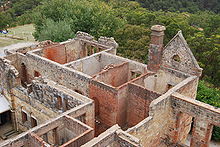
 Ruins of the summer residence of the Governor of South Australia, which was destroyed in the fire | |
| Date(s) | January 2, 1955 |
| Location | South Australia |
| Statistics | |
| Burned area | 600 square miles (160,000 ha)[1] |
| Impacts | |
| Deaths | 2 |
| Non-fatal injuries | 50+[2] |
| Structures destroyed | 40 houses |
| Ignition | |
| Cause | Downed power lines |
The Black Sunday bushfires were a series of bushfires that broke out across South Australia on 2 January 1955.[3] Extreme morning temperatures coupled with strong north-westerly winds contributed to the breakout of numerous fires in the Adelaide Hills, Jamestown, Waterloo, Kingston and Millicent.[citation needed] Most were caused by sparks from powerlines downed by the wind.[3]
Around 1,000 Emergency Fire Service volunteers from 60 brigades were tasked to the fires, but were overwhelmed. At 10am, the EFS head office requested urgent public assistance. Around 2,500 citizens volunteered. The fires were contained by 9:30pm, thanks largely to a fortuitous change in the weather and widespread public assistance.[3]
The fires resulted in two deaths, destroyed 40 homes and numerous other buildings, and caused more than four million dollars worth of property damage, most notably the destruction of the Governor's summer residence at Marble Hill. Governor Robert George, his family and staff were lucky to escape with their lives. The Premier, Sir Thomas Playford, also narrowly escaped death, sheltering with five other men in a patch of hoed earth near Cherryville.[4] The burnt area was estimated at as much as 600 square miles (160,000 ha) stretching from One Tree Hill to Strathalbyn,[1] however other sources put the area at closer to 150 sq mi (39,000 ha).[5]
References
- ^ a b Alison Painter. "2 January 1955 Black Sunday". Professional Historians Association (South Australia). Retrieved 15 May 2013.
- ^ "Wide Damage In South Australia". The Canberra Times (ACT : 1926 - 1995). ACT: National Library of Australia. 4 January 1955. p. 1. Retrieved 15 May 2013.
- ^ a b c "Archived copy" (PDF). Archived from the original (PDF) on 2008-07-21. Retrieved 2009-01-24.
{{cite web}}: Unknown parameter|deadurl=ignored (|url-status=suggested) (help)CS1 maint: archived copy as title (link) - ^ "BUSH FIRES RAGE IN S. AUSTRALIA". The Canberra Times (ACT : 1926 - 1995). ACT: National Library of Australia. 3 January 1955. p. 1. Retrieved 15 May 2013.
- ^ http://www.cfs.sa.gov.au/site/bushfire_history.jsp
See also
34°54′40″S 138°42′26″E / 34.911185°S 138.70735°E
