Brás
Appearance
23°32′28″S 46°36′58″W / 23.541°S 46.616°W
Brás | |
|---|---|
 District of the city of São Paulo | |
| Country | |
| State | |
| Municipality | |
| Subprefecture | Mooca |
| Area | |
| • Total | 3.5 km2 (1.4 sq mi) |
| Population (2010) | |
| • Total | 29,265 |
| • Density | 8,361/km2 (21,650/sq mi) |
| Website | Subprefecture of Mooca |
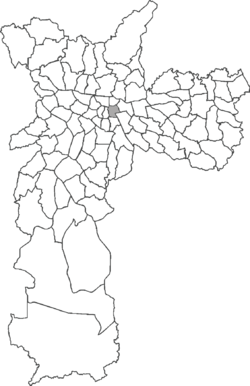
Brás is one of 96 districts in the city of São Paulo, Brazil.[1] Administratively part of the Southeast Zone of São Paulo, Brás is located immediately to the east of the historic downtown in the Subprefecture of Mooca. The district is an area of heavy industry with many factories and warehouses, known as a center of textile manufacturing.
Two sets of railroad tracks cut across the district; the Brás rail station serves Metrô Line 3 (red) and three commuter rail lines operated by CPTM: Line 10 (turquoise), 11 (coral), and 12 (sapphire).
References
- ^ "Dados Demográficos dos Distritos pertencentes as Subprefeituras". prefeitura.sp.gov.br (in Portuguese). City of São Paulo. Retrieved 28 December 2014.
External links

