
Brillion, Wisconsin
Brillion, Wisconsin | |
|---|---|
 | |
 Location of Brillion, Wisconsin | |
| Country | United States |
| State | Wisconsin |
| County | Calumet |
| Area | |
| • Total | 2.75 sq mi (7.12 km2) |
| • Land | 2.73 sq mi (7.07 km2) |
| • Water | 0.02 sq mi (0.05 km2) |
| Elevation | 830 ft (253 m) |
| Population | |
| • Total | 3,148 |
| • Estimate (2012[4]) | 3,186 |
| • Density | 1,153.1/sq mi (445.2/km2) |
| Time zone | UTC-6 (Central (CST)) |
| • Summer (DST) | UTC-5 (CDT) |
| Area code | 920 |
| FIPS code | 55-09725[5] |
| GNIS feature ID | 1562211[2] |
| Website | www |
Brillion is a city in Calumet County in the U.S. state of Wisconsin. The population was 3,148 at the 2010 census. The city is located within the Town of Brillion, though it is politically independent.
Brillion is named after the town of Brilon, in Germany.[6]
Geography
Brillion is located at 44°10′30″N 88°3′57″W / 44.17500°N 88.06583°W (44.175114, -88.0661).[7]
According to the United States Census Bureau, the city has a total area of 2.75 square miles (7.12 km2), of which, 2.73 square miles (7.07 km2) is land and 0.02 square miles (0.05 km2) is water.[1]
Demographics
| Census | Pop. | Note | %± |
|---|---|---|---|
| 1880 | 278 | — | |
| 1890 | 582 | 109.4% | |
| 1900 | 855 | 46.9% | |
| 1910 | 998 | 16.7% | |
| 1920 | 1,102 | 10.4% | |
| 1930 | 1,167 | 5.9% | |
| 1940 | 1,200 | 2.8% | |
| 1950 | 1,390 | 15.8% | |
| 1960 | 1,783 | 28.3% | |
| 1970 | 2,588 | 45.1% | |
| 1980 | 2,907 | 12.3% | |
| 1990 | 2,840 | −2.3% | |
| 2000 | 2,937 | 3.4% | |
| 2010 | 3,148 | 7.2% | |
| 2015 (est.) | 3,142 | [8] | −0.2% |
2010 census
As of the census[3] of 2010, there were 3,148 people, 1,298 households, and 851 families residing in the city. The population density was 1,153.1 inhabitants per square mile (445.2/km2). There were 1,349 housing units at an average density of 494.1 per square mile (190.8/km2). The racial makeup of the city was 97.1% White, 0.2% African American, 0.5% Native American, 0.2% Asian, 0.9% from other races, and 1.2% from two or more races. Hispanic or Latino of any race were 2.8% of the population.
There were 1,298 households of which 32.8% had children under the age of 18 living with them, 52.7% were married couples living together, 7.8% had a female householder with no husband present, 5.1% had a male householder with no wife present, and 34.4% were non-families. 29.7% of all households were made up of individuals and 15.7% had someone living alone who was 65 years of age or older. The average household size was 2.42 and the average family size was 3.01.
The median age in the city was 37.8 years. 25.5% of residents were under the age of 18; 7% were between the ages of 18 and 24; 27.1% were from 25 to 44; 24.1% were from 45 to 64; and 16.2% were 65 years of age or older. The gender makeup of the city was 49.4% male and 50.6% female.
2000 census
As of the census[5] of 2000, there were 2,937 people, 1,155 households, and 818 families residing in the city. The population density was 1,128.8 people per square mile (436.1/km²). There were 1,230 housing units at an average density of 472.7 per square mile (182.7/km²). The racial makeup of the city was 98.64% White, 0.72% Native American, 0.17% Asian, 0.17% from other races, and 0.31% from two or more races. 0.51% of the population were Hispanic or Latino of any race.
There were 1,155 households out of which 32.6% had children under the age of 18 living with them, 60.6% were married couples living together, 7.7% had a female householder with no husband present, and 29.1% were non-families. 25.2% of all households were made up of individuals and 12.3% had someone living alone who was 65 years of age or older. The average household size was 2.53 and the average family size was 3.03.
In the city the population was spread out with 26.3% under the age of 18, 8.2% from 18 to 24, 29.1% from 25 to 44, 21.9% from 45 to 64, and 14.6% who were 65 years of age or older. The median age was 36 years. For every 100 females there were 95.7 males. For every 100 females age 18 and over, there were 93.2 males.
The median income for a household in the city was $46,633, and the median income for a family was $52,989. Males had a median income of $37,106 versus $24,318 for females. The per capita income for the city was $20,754. About 1.6% of families and 2.5% of the population were below the poverty line, including 0.8% of those under age 18 and 7.1% of those age 65 or over.
Education
Brillion High School is the area's high school.
Brillion was the Wisconsin State Football Champions in Division 5 of the 2003, 2004, and 2010 seasons. They also were the Division 4 State Football Champions in 1984. Also with a Semi-final runner-up in 2005 and 2009 for football. Brillion Basketball Team has been successful of late. In 2001, the girls' team took second in Division 3. Also the 2006-2007 boys' team was given a berth in a sectional playoff game after winning regionals only to be defeated. Both the girls' and boys' basketball teams of 2009 made it to state in Division 3.
Images
-
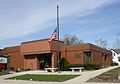
 City hall
 -
 Brillion Public Library
 -
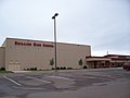
 Center of Brillion
 -
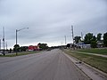 Looking west on U.S. Route 10
 -


Notable people
- Charles A. Barnard, Wisconsin State Assemblyman
- Charles R. Barnard, Wisconsin State Assemblyman
- Jill Lajdziak, general manager of General Motors Saturn division
- Isaac N. McComb, Wisconsin State Assemblyman
- Gerald L. Miller, U.S. Marine Corps general
- Victor A. Tiedjens, scientist
References
- ^ a b "US Gazetteer files 2010". United States Census Bureau. Archived from the original on 2012-01-24. Retrieved 2012-11-18.
{{cite web}}: Unknown parameter|deadurl=ignored (|url-status=suggested) (help) - ^ a b "US Board on Geographic Names". United States Geological Survey. 2007-10-25. Retrieved 2008-01-31.
- ^ a b "American FactFinder". United States Census Bureau. Retrieved 2012-11-18.
- ^ "Population Estimates". United States Census Bureau. Archived from the original on 2013-06-17. Retrieved 2013-06-24.
{{cite web}}: Unknown parameter|deadurl=ignored (|url-status=suggested) (help) - ^ a b "American FactFinder". United States Census Bureau. Archived from the original on 2013-09-11. Retrieved 2008-01-31.
{{cite web}}: Unknown parameter|deadurl=ignored (|url-status=suggested) (help) - ^ Chicago and North Western Railway Company (1908). A History of the Origin of the Place Names Connected with the Chicago & North Western and Chicago, St. Paul, Minneapolis & Omaha Railways. p. 46.
- ^ "US Gazetteer files: 2010, 2000, and 1990". United States Census Bureau. 2011-02-12. Retrieved 2011-04-23.
- ^ "Annual Estimates of the Resident Population for Incorporated Places: April 1, 2010 to July 1, 2015". Retrieved July 2, 2016.
- ^ "Census of Population and Housing". Census.gov. Archived from the original on May 11, 2015. Retrieved June 4, 2015.
{{cite web}}: Unknown parameter|deadurl=ignored (|url-status=suggested) (help)
External links
- City of Brillion
- Sanborn fire insurance maps: 1894 1900 1906 1913
Municipalities and communities of Calumet County, Wisconsin, United States | ||
|---|---|---|
| Cities |  | |
| Villages | ||
| Towns | ||
| CDPs | ||
| Other communities | ||
| Ghost town | ||
| Footnotes | ‡This populated place also has portions in an adjacent county or counties | |