
Browns Summit, North Carolina
Browns Summit | |
|---|---|
| Country | United States |
| State | North Carolina |
| County | Guilford |
| Time zone | UTC-5 (Eastern (EST)) |
| • Summer (DST) | UTC-4 (EDT) |
Browns Summit (sometimes called Brown Summit) is a small unincorporated community in Guilford County, North Carolina, United States. It lies just northeast of Greensboro, near the intersections of North Carolina Highway 150 and U.S. Route 29 along the future Interstate 785 in Guilford County, Latitude 36.212°N & Longitude -79.713°W. Elevation is 801 feet.[1] The single public elementary school is a part of the Guilford County school system. The zip code for Browns Summit is 27214 and it is in the 336 area code.
It is a fast-growing area due to the proximity to Greensboro and Reidsville, North Carolina, with many new housing developments in progress, particularly on the NC Hwy 150 corridor. Once the Greensboro Urban Loop is completed, Browns Summit will lie a few miles outside of the loop.
Statistics
As of 2006, it has a population of 7,852. Average household income is $45,281, compared to the NC average of $44,519 and US average of $44,684. Unemployment is slightly higher than the national average of 5%, at 6% (2006 rates). The cost of living is approximately 83% of the average in the US. [2]
Browns Summit (1) "community in north Guilford County. Alt. 805. Land here acquired by Jesse Brown, 1858. Named for him in 1863 when Richmond and Danville Railroad was built, because the Brown farm was the highest point on the line." Powell, p. 66. (2) a post office from 1871 to the present; located in northeast Monroe Township.
See also
References
- ^ http://www.epodunk.com/cgi-bin/genInfo.php?locIndex=274962 Epodunk Community Profile
- ^ http://www.greatschools.net/city/Browns_Summit/NC Brown Summit Schools and Other Info
Municipalities and communities of Guilford County, North Carolina, United States | ||
|---|---|---|
| Cities | 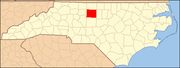 | |
| Towns | ||
| CDPs | ||
| Unincorporated communities | ||
| Footnotes | ‡This populated place also has portions in an adjacent county or counties | |