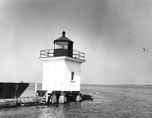
Cape Vincent Breakwater Light
Appearance
 Cape Vincent Breakwater Lighthouse | |
 | |
| Location | Originally on the Breakwater at Cape Vincent Harbor Cape Vincent, New York |
|---|---|
| Coordinates | 44°07′10″N 76°19′56″W / 44.1194°N 76.3322°W |
| Tower | |
| Constructed | 1901 |
| Height | 26 feet (7.9 m) |
| Shape | Square |
| Markings | White square enclosed structure |
| Fog signal | None |
| Light | |
| First lit | 1912 |
| Deactivated | 1951 |
| Lens | Fifth Order fresnel lens |
| Characteristic | Flashing red, dark sector; illuminated 307° of the horizon; dark sectors lying towards shore (as of 1941) |
Cape Vincent Breakwater Light was a lighthouse on the breakwater protecting the harbor in the town of Cape Vincent, New York.[2]
It has been moved to the Town Highway Department on New York State Route 12E.
It should not be confused with the nearby Tibbetts Point Light, an active lighthouse also in Cape Vincent.
References
- ^ ARLHS World List of Lights
- ^ Note that while "Historic Light Station Information and Photography: New York". United States Coast Guard Historian's Office. Archived from the original on 2017-05-01. describes two lights at this location, Cape Vincent Breakwater East End Light and Cape Vincent Breakwater West End Light, and the breakwater runs east and west so it is possible that there were two lights, the two descriptions are identical, including both the light characteristics and the sectors. It is extremely unlikely that two lights at opposite ends of a breakwater would have the same characteristic, and, therefore, the web site is almost certainly wrong.
External links

