Cherry River (Quebec)
Appearance
| Cherry River | |
|---|---|
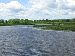
 A riverbend in the Cherry River | |
 | |
| Native name | Rivière aux Cerises Error {{native name checker}}: parameter value is malformed (help) |
| Location | |
| Country | Canada |
| Location | Magog, Quebec |
| Physical characteristics | |
| Mouth | |
• location | Lake Memphremagog |
The Cherry River or Rivière aux Cerises is a river in Magog, Quebec that is part of the Lake Memphremagog watershed. The river was flooded by the creation of dams in the late 19th century, creating a permanent wetland around it.[2]
References
- ^ "Banque de noms de lieux du Québec: Reference number 11964". toponymie.gouv.qc.ca (in French). Commission de toponymie du Québec.
- ^ Farfan, Matthew. "The Cherry River Marsh, Magog". Townships Heritage Web Magazine. Retrieved 14 July 2014.
External links
