
Chewacla, Alabama
Chewacla | |
|---|---|
 Chewacla Location within the state of Alabama  Chewacla Chewacla (the United States) | |
| Coordinates: 32°37′12″N 85°20′14″W / 32.62000°N 85.33722°W | |
| Country | United States |
| State | Alabama |
| County | Lee |
| Elevation | 771 ft (235 m) |
| Time zone | UTC-6 (CST) |
| • Summer (DST) | UTC-6 (EDT) |
| GNIS feature ID | 156176[1] |
Chewacla, also known as Yongesborough, is an unincorporated community in the northeast corner of Lee County, Alabama, United States.
History
The name Chewacla is derived from the Hitchiti word sawackla, with sawi meaning "racoon" and ukli meaning "town".[2] Chewacla was located on the Central of Georgia Railway. It was once home to the Chewacla Lime Works, which operated a quarry.[3] A specific type of marble, known as Chewacla marble, was mined in this quarry. Chewacla marble was described as "a highly crystalline dolomite, for most part a beautiful pearly white stone".[4] Gneiss was also mined in the quarry and used to make millstones.[5]
Chewacla was the location of one of the first Rosenwald schools in Alabama.[6]
A post office operated under the name Yongesborough from 1859 to 1886 and under the name Chewacla from 1886 to 1907.[7]
Gallery
Below are photographs taken in Chewacla as part of the Historic American Buildings Survey:
-
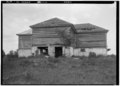 Convict quarters, Chewacla Lime Works
 -
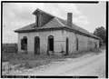 Old commissary building, Chewacla Lime Works
 -
 Old mule stable, Chewacla Lime Works
 -
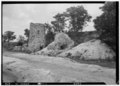 Remains of old lime kilns
 -
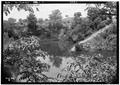 Old lime pit


References
- ^ U.S. Geological Survey Geographic Names Information System: Chewacla, Alabama
- ^ Read, William A. (1984). Indian Place Names in Alabama. Tuscaloosa: The University of Alabama Press. p. 15. ISBN 0-8173-0231-X.
- ^ List of Quarries in Alabama & Quarry Links, Photographs and Articles
- ^ Lexicon of Geologic Names of the United States: A-L. U.S. Government Printing Office. 1938. p. 423.
- ^ Charles D. Hockensmith (12 May 2009). The Millstone Industry: A Summary of Research on Quarries and Producers in the United States, Europe and Elsewhere. McFarland. p. 78. ISBN 978-0-7864-5380-1.
- ^ Ellen Weiss; Robert Robinson Taylor (2012). Robert R. Taylor and Tuskegee: An African American Architect Designs for Booker T. Washington. NewSouth Books. p. 257. ISBN 978-1-58838-248-1.
- ^ "Lee County". Jim Forte Postal History. Retrieved 1 January 2015.
External links
Municipalities and communities of Lee County, Alabama, United States | ||
|---|---|---|
| Cities | 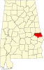 | |
| Towns | ||
| Unincorporated communities | ||
| Footnotes | ‡This populated place also has portions in an adjacent county or counties | |
This Alabama state location article is a stub. You can help Wikipedia by expanding it. |