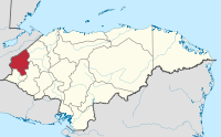
Copán Department
Appearance
Copán | |
|---|---|
Department | |
 | |
| Coordinates: 14°46′N 88°47′W / 14.767°N 88.783°W | |
| Country | |
| Municipalities | 23 |
| Villages | 337 |
| Founded | 28 May 1869 |
| Seat | Santa Rosa de Copán |
| Government | |
| • Type | Departmental |
| Area | |
| • Total | 3,239 km2 (1,251 sq mi) |
| Population (2015)[1] | |
| • Total | 382,722 |
| • Density | 120/km2 (310/sq mi) |
| Time zone | UTC-6 (CDT) |
| Postal code | 41101, 41202 |
| ISO 3166 code | HN-CP |
| Statistics derived from Consult INE online database: Population and Housing Census 2013[2] | |
Copán is one of the departments in the western part of Honduras. The departmental capital is the town of Santa Rosa de Copán. The department is well known for its tobacco and fine cigars.
The department is famous for its Pre-Columbian archaeological site at Copán, one of the greatest cities of the Maya civilization.
The department of Copán covers a total surface area of 3,242 km2 and, in 2015, had an estimated population of about 382,722 people.
Municipalities
References
- ^ "GeoHive - Honduras extended".
- ^ "Consulta Base de datos INE en línea: Censo de Población y Vivienda 2013" [Consult INE online database: Population and Housing Census 2013]. Instituto Nacional de Estadística (INE) (in Spanish). El Instituto Nacional de Estadística (INE). 1 August 2018. Retrieved 2018-09-13.
