Cubero, New Mexico
Appearance
Cubero, New Mexico | |
|---|---|
| Country | United States |
| State | New Mexico |
| County | Cibola |
| Area | |
| • Total | 9.385 sq mi (24.31 km2) |
| • Land | 9.385 sq mi (24.31 km2) |
| • Water | 0 sq mi (0 km2) |
| Elevation | 6,217 ft (1,895 m) |
| Population | |
| • Total | 289 |
| • Density | 31/sq mi (12/km2) |
| Time zone | UTC-7 (Mountain (MST)) |
| • Summer (DST) | UTC-6 (MDT) |
| ZIP code | 87014 |
| Area code | 505 |
| GNIS feature ID | 898751[3] |

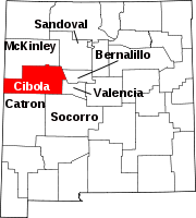
Cubero is a census-designated place in Cibola County, New Mexico, United States. Its population was 289 as of the 2010 census. Cubero has a post office with ZIP code 87014.[4][5] The town was founded by Mexicans and was along the route of the Santa Fe Railroad's first transcontinental rail line through the Southwestern United States.
References
- ^ "US Gazetteer files: 2010, 2000, and 1990". United States Census Bureau. 2011-02-12. Retrieved 2011-04-23.
- ^ "American FactFinder". United States Census Bureau. Archived from the original on 2013-09-11. Retrieved 2011-05-14.
{{cite web}}: Unknown parameter|deadurl=ignored (|url-status=suggested) (help) - ^ "Cubero". Geographic Names Information System. United States Geological Survey, United States Department of the Interior.
- ^ United States Postal Service (2012). "USPS - Look Up a ZIP Code". Retrieved 2012-02-15.
- ^ "Postmaster Finder - Post Offices by ZIP Code". United States Postal Service. Retrieved August 10, 2013.

