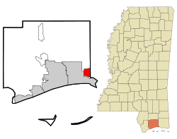
D'Iberville, Mississippi
D'Iberville, Mississippi | |
|---|---|
 Location of D'Iberville, Mississippi | |
| Country | United States |
| State | Mississippi |
| County | Harrison |
| Area | |
| • Total | 7.3 sq mi (19.0 km2) |
| • Land | 7.1 sq mi (18.3 km2) |
| • Water | 0.3 sq mi (0.7 km2) |
| Elevation | 13 ft (4 m) |
| Population (2010) | |
| • Total | 9,486 |
| • Density | 1,300/sq mi (500/km2) |
| Time zone | UTC-6 (Central (CST)) |
| • Summer (DST) | UTC-5 (CDT) |
| ZIP code | 39540 |
| Area code | 228 |
| FIPS code | 28-19180 |
| GNIS feature ID | 0669069 |
| Website | diberville |
D'Iberville /diːˈaɪbərvɪl/ is a city in Harrison County, Mississippi, United States, immediately north of Biloxi, across the Back Bay. As of the 2010 census, it had a population of 9,486.[1] It is part of the Gulfport–Biloxi Metropolitan Statistical Area.
It is named after French explorer Pierre Le Moyne d'Iberville, who arrived at the area in 1699. Almost 300 years later, D'Iberville officially became a city in 1988.[2]
D'Iberville was one of the Gulf Coast cities hit and extensively damaged by Hurricane Katrina in 2005. As a result of an initiative by the Congress for the New Urbanism under the sponsorship of Governor Haley Barbour and the State of Mississippi, the City of D'Iberville received town design consulting services from some of the most prestigious urban designers in the country.[3] Since then, the City of D’Iberville has been working with Jaime Correa and Associates on the implementation of its master plan, on a full-fledged New Urbanism SmartCode for its downtown area, and on the implementation of mixed-use neighborhoods and main street.[4]
Geography
D'Iberville is located at 30°26′13″N 88°53′51″W / 30.437048°N 88.897619°W.[5]
According to the United States Census Bureau, the city has a total area of 7.3 square miles (19.0 km2), of which 7.1 square miles (18.3 km2) is land and 0.27 square miles (0.7 km2), or 3.84%, is water.[6]
Demographics
| Census | Pop. | Note | %± |
|---|---|---|---|
| 1990 | 6,566 | — | |
| 2000 | 7,608 | 15.9% | |
| 2010 | 9,486 | 24.7% | |
| 2015 (est.) | 11,400 | [7] | 20.2% |

As of the census[9] of 2000, there were 7,608 people, 2,827 households, and 1,976 families residing in the city. The population density was 1,604.1 people per square mile (619.7/km²). There were 3,088 housing units at an average density of 651.1 per square mile (251.5/km²). The racial makeup of the city was 78.21% White, 11.40% African American, 0.37% Native American, 7.03% Asian, 0.01% Pacific Islander, 0.85% from other races, and 2.13% from two or more races. Hispanic or Latino of any race were 2.64% of the population.
There were 2,827 households out of which 34.1% had children under the age of 18 living with them, 49.6% were married couples living together, 15.2% had a female householder with no husband present, and 30.1% were non-families. 23.0% of all households were made up of individuals and 5.6% had someone living alone who was 65 years of age or older. The average household size was 2.69 and the average family size was 3.17.
In the city the population was spread out with 27.0% under the age of 18, 9.6% from 18 to 24, 32.3% from 25 to 44, 22.5% from 45 to 64, and 8.6% who were 65 years of age or older. The median age was 34 years. For every 100 females there were 99.5 males. For every 100 females age 18 and over, there were 96.9 males.
The median income for a household in the city was $34,700, and the median income for a family was $40,347. Males had a median income of $26,774 versus $22,259 for females. The per capita income for the city was $15,846. About 9.0% of families and 11.7% of the population were below the poverty line, including 16.9% of those under age 18 and 9.5% of those age 65 or over.
As of January 2012, the mayor of D'Iberville is Russell "Rusty" Quave. He has held this position since 1993 for over two decades.
Public schools
The city of D'Iberville is served by the Harrison County School District.
- D'Iberville High School
- D'Iberville Middle School
- D'Iberville Elementary School
References
- ^ "Profile of General Population and Housing Characteristics: 2010 Demographic Profile Data (DP-1): D'Iberville city, Mississippi". U.S. Census Bureau, American Factfinder. Archived from the original on September 11, 2013. Retrieved May 15, 2012.
{{cite web}}: Unknown parameter|deadurl=ignored (|url-status=suggested) (help) - ^ Archives | City of D'Iberville - Dev
- ^ Mississippi Renewal Forum
- ^ Philip Langdon, "Katrina Cottages funded; implementation questions remain", New Urban News, July/August 2006
- ^ "US Gazetteer files: 2010, 2000, and 1990". United States Census Bureau. 2011-02-12. Retrieved 2011-04-23.
- ^ "Geographic Identifiers: 2010 Demographic Profile Data (G001): D'Iberville city, Mississippi". U.S. Census Bureau, American Factfinder. Archived from the original on September 11, 2013. Retrieved May 15, 2012.
{{cite web}}: Unknown parameter|deadurl=ignored (|url-status=suggested) (help) - ^ "Annual Estimates of the Resident Population for Incorporated Places: April 1, 2010 to July 1, 2015". Retrieved July 2, 2016.
- ^ "Census of Population and Housing". Census.gov. Archived from the original on May 11, 2015. Retrieved June 4, 2015.
{{cite web}}: Unknown parameter|deadurl=ignored (|url-status=suggested) (help) - ^ "American FactFinder". United States Census Bureau. Archived from the original on 2013-09-11. Retrieved 2008-01-31.
{{cite web}}: Unknown parameter|deadurl=ignored (|url-status=suggested) (help)
External links
 D'Iberville travel guide from Wikivoyage
- City of D'Iberville official website
- History of D'Iberville
- D'Iberville Citizens' Master Plan

