
Dharamshala
Dharamshala
Dharamsala | |
|---|---|
town | |
| Population (2001) | |
| • Total | 19,034 |
Dharamsala or Dharamshāla, (literally "Rest House"; Hindi: धर्मशाला; Tibetan: དྷ་རམ་ས་ལ་; Hindi pronunciation /d̪ʱərmʃɑlɑ/) is a town and a municipal council in Kangra district in the northern regions of India in the state of Himachal Pradesh.
The town is notable as the capital of the Central Tibetan Administration, a Tibetan government in exile led by Tenzin Gyatso, the 14th and current Dalai Lama. The government's headquarters are located in McLeod Ganj, a suburb that is also referred to as Upper Dharamsala or "Little Lhasa".
History
Dharamsala came into existence in 1849, it was selected as a site to accommodate a native regiment that was being raised in the town. Dharamsala originally formed a subsidiary cantonment for the troops stationed at Kangra Valley was fully occupied by its garrison and there was insufficient space for the civil station, a search for an alternate location was made. The ideal location for the cantonment was found at the slopes of the Dhauladhar, upon which stood an old Hindu sanctuary or 'Dharamsala' the name adopted for the town.
Dharamsala has been connected with Hinduism and Buddhism for a long time, with many monasteries having been established there in the past, built by Tibetan immigrants in the 19th century. The local Gaddi people are Hindu, and for the most part worship many gods and goddesses, principally Durga and Shiva.
In 1848, the area was annexed by the British, and a year later, a military garrison was established in the town. Dharamsala eventually became the administrative capital of Kangra District in 1852. The second Viceroy of India died here in 1863 and is buried in the cemetery of St. John in the Wilderness. It became a popular hill station for the British working in or near Delhi, offering a cool respite during the hot summer months.

However, the town was virtually destroyed in a massive earthquake in 1905, which killed an estimated 20,000 people. Not only the town was devastated, but the nearby town Kangra was also ruined. After this, the British moved their summer headquarters to Shimla (also written Simla) which, though not far away, is off the main fault line and, therefore, less likely to experience a serious earthquake. Dharamsala still experiences frequent minor earthquakes.
When the Dalai Lama left Tibet, Indian Prime Minister Jawaharlal Nehru offered to permit him and his followers to establish a "government-in-exile" in Dharamsala in 1960. Since then, many Tibetan exiles have settled in the town, numbering several thousand. Most of these exiles live in Upper Dharamsala, or McLeod Ganj, where they established monasteries, temples and schools. The town is sometimes known as "Little Lhasa", after the Tibetan capital city, and has become an important tourist destination with many hotels and restaurants, creating a resurgence in tourism and commerce.
Since 2002, Dharamsala has hosted a Miss Tibet beauty contest. The winter capital Dharamsala has its secretariat at Tapovan and the government would run for 2 months from there.
Geography

Dharamsala is located at 32°13′00″N 76°19′12″E / 32.2167°N 76.32°E[1], with an average elevation of 1457 metres (4780 feet). The area covered by Dharamsala is almost 29 km².
Dharamsala is in the Kangra valley, in the Dhauladhar mountains, and became the capital of the Kangra District in 1852. It can be accessible from Pathankot which is 120 km away. The nearest railway connection to Dharamsala is Kangra. The nearest airport is Gaggal at Kangra which is just 15km from Dharamsala. There is a daily flight from Dharamsala to Delhi.
The town is divided between McLeod Ganj or Upper Dharamsala (which retains a British colonial atmosphere), and Lower Dharamsala (the commercial centre). Upper Dharamsala (elevation about 1,700 m or 5,580 ft) is about 9 kilometers (5.6 miles) from Lower Dharmsala by road and is some 460 m (1,510 ft) higher.
McLeod Ganj, or Upper Dharamsala, is the residence of Tenzin Gyatso, the current Dalai Lama. A substantial community of Tibetan exiles resides in the town. There is a small Anglican church, St. John in the Wilderness, featuring stained-glass windows, just a few hundred metres from McLeod Ganj. Lord Elgin (James Bruce, 8th Earl of Elgin), one of the British viceroys, is buried here, as is Francis Younghusband.
Demographics
As of the 2001 India census,[2] Dharamsala had a population of 19,034. Males constitute 55% of the population and females 45%. Dharamsala has an average literacy rate of 77%, higher than the national average of 59.5%: male literacy is 80% and, female literacy is 73%. In Dharamsala, 9% of the population is under 6 years of age.
Famous residents
- Tenzin Gyatso, 14th and current Dalai Lama
- Namrata Singh Gujral - Hollywood Actress
Climate
During the months of December and January, snow and sleet is common. Summer temperatures range from 22 °C to 38 °C. It is very cold in winter as Dhauladar range of hills, at over 15000 feet, is close by and covered with thick snow during winter and sometimes in Autumn and Spring. The natural features surrounding the town include rich forests of Pine and Deodars. Rice, wheat and tea are grown around Dharamsala.
Connectivity
- The nearest airport is Gaggal Airport, it is an hour drive from Dharamsala.
- Air conditioned, deluxe buses ply from major cities like : Chandigarh, Delhi, Shimla etc.
- Nearest railway station is Chakki Bank at Pathankot, which is 3 hours from Dharamsala and is well connected to rest of Northern India their is an other rail way line from Pathankot to jogindernagar
which is a part of Mandi distt. of HP. and it is an narrow gadge line and for going to Dharmshala nearest railway station is Chamunda Marg which is 1/2 hours from Dharamsala and is well connected by the road to the other parts of country( Chasmunda is an famous SHAKTIPITHA IN the world )
Places of attraction
- St.John's Church
- Triund (2975 m)
- Kunal Pathri
- brajeshwari temple
- dari
- khaniyara
- aghanjar mahadev
- indru nag temple
- golf course (yol cant)
- kareri lake
- lam dal lake
- Chinmaya Tapovan
- Dal lake
- Dharamkot (2100 m)
- Bhagsunath
- Tatwani and Machhrial
- Chamunda Mandir
- Trilokpur
- Masrur (rock temple)
- Nurpur[3]
- Norbulingka Institute
- Sidhbari
- Adi Shakti Temple , Naddi
- Historical fort of kangra in Purana Kangra.
- HARIPUR VILLAGE [[1]]http://en.wikipedia.org/wiki/User_talk:Kaundl_aru
Gallery
-
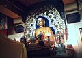 Shakyamuni Buddha at the monastery of Dalai Lama Tenzin Gyatso.
 -
 Prayer Drums, Dharamsala
 -
 McLeod Ganj main street
 -
 Mules carrying locally mined slate, a material used on most roofs in the area.
 -
 Stupa & prayer wheels. Main street, McLeod Ganj, 2004
 -
 View from Dharamkot: McLeod Ganj, Lower Dharamsala & Beas River. Sketch by Alfred Hallett, c. 1980
 -
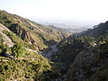 View outside the valley at Dharamsala
 -
A collection of Buddhism's teachings in Dharamshala, India.
.jpg)


References
- Verma, V. 1996. Gaddis of Dhauladhar: A Transhumant Tribe of the Himalayas. Indus Publishing Co., New Delhi.
- Handa, O. C. 1987. Buddhist Monasteries in Himachal Pradesh. Indus Publishing Co., New Delhi. ISBN 81-85182-03-5.