Dungeness
Dungeness is a headland on the coast of Kent, England, formed largely of a shingle beach in the form of a cuspate foreland. It shelters a large area of low-lying land, Romney Marsh. Dungeness is also the name given to a "village" situated along the beach, and to an important ecological site on the same location.
Name Origin
The name Dungeness derives from Old Norse nes: "headland", with the first part probably connected with the nearby Denge Marsh. Popular etymology ascribes a French origin to the toponym, giving an interpretation as "dangerous nose".
Ecology
Dungeness is one of the largest expanses of shingle in the world. It is of international conservation importance for its geomorphology, plant and invertebrate communities and birdlife. This is recognised and protected mostly through its conservation designations as a National Nature Reserve (NNR), a Special Protection Area (SPA), a Special Area of Conservation (SAC) and part of the Site of Special Scientific Interest (SSSI) known as Dungeness, Romney Marsh and Rye Bay.
There is a remarkable and unique variety of wildlife living at Dungeness, with over 600 different types of plant (a third of all those found in Britain). It is one of the best places in Britain to find insects such as moths, bees and beetles, and spiders; many of these are very rare, some found nowhere else in Britain.
The flooded gravel pits, both brackish and fresh water, provide an important refuge for many migratory and coastal bird species. The RSPB has a bird sanctuary there and every year thousands of bird watchers descend on the peninsula to catch a glimpse of a rare bird from the bird observatory.
One of the most remarkable features of the site is an area known as 'the patch' or, by anglers, as 'the boil'. The waste hot water and sewage from the nuclear power stations are pumped into the sea through two outfall pipes, enriching the biological productivity of the sea bed and attracting seabirds from miles around.
Lighthouses

There have been five lighthouses at Dungeness.
At first only a beacon was used to give warning to sailors, but this gave way to a proper lighthouse during the reign of James I in 1615. As the sea retreated, this had to be replaced in 1635 by a new lighthouse nearer to the water’s edge. As more shingle was thrown up, a new and more up-to-date lighthouse was built near the sea in 1792. In 1901 lighthouse number four was commissioned; then in 1961 its modern successor, the black and white lighthouse number five, was commissioned and the Old Lighthouse became a tourist attraction. Its 169 steps give visitors a bird’s eye view of the shingle beach.
Power stations
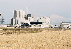
There are two nuclear power stations at Dungeness, the first built in 1965 and the second in 1983. They are within a wildlife sanctuary deemed a Site of Special Scientific Interest and birds flourish in the warmer water created by the station's outflow.[citation needed]

Tours of the power station stopped due to security fears after September 11, 2001. The visitors' centre closed in 2003. The centre has been rebuilt as office.
The older power station closed on 31 December 2006,[1] but the newer station has had its licence extended to 2018.[2]
Communications
Roads
There are two roads giving access: one from Lydd in the north-west; and from the north at New Romney along the coast.
Railways
A branch from the Marshlink Line at Appledore to New Romney was opened by the South Eastern Railway: it had a short branch to a station at Dungeness, which closed to passengers on 4 July 1937; it was closed completely when the Lydd to New Romney section closed on 6 March 1967.[3] The remaining section to Lydd transports waste from the power stations. The track is shown on Ordnance Survey map sheet 89, and a number of cottages have been constructed from old carriages.
The Romney, Hythe and Dymchurch Railway, opened to New Romney in 1927, was extended to Dungeness a year later, and continues to operate.
Defence uses
The beach and marshes have been used for military training and there are marked Danger areas.
Acoustic mirrors

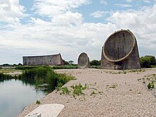
Denge is the site of a set of acoustic mirrors, known as the "Listening Ears". Built between 1928 and 1930, the three massive concrete structures formed an experimental early warning system that aimed to detect invading aircraft by focusing sound waves. The site was chosen as being one of the quietest in Britain. Their different forms are evidence of their experimental nature; they were not particularly effective and were abandoned when radar became available. English Heritage and English Nature have joined forces to provide public access to the site.
Operation Pluto
In 1944 some of the world's first submarine oil pipelines were laid between Dungeness and France in Operation Pluto. The lines from Dungeness were part of a network called Dumbo and ran to Ambleteuse in France.
The "Village"

Dungeness is not truly a village, more a scattered collection of dwellings. Some of the homes, small wooden houses in the main, many built around old railway coaches, are owned and lived in by fishermen, whose boats lie on the beach; some are occupied by people trying to escape the pressured outside world.
Perhaps the most famous house is Prospect Cottage, formerly owned by the late artist and film director Derek Jarman. The cottage itself is painted black, with a poem written on one side in black lettering. The garden however is the main attraction. Reflecting the bleak, windswept landscape of the peninsula Derek Jarman's Garden is made of pebbles, driftwood, scrap metal and a few hardy plants. A book "Derek Jarman's Garden" is available, ISBN 0-500-01656-9.
There are more solidly-built houses around the site of the power stations.
The Landscape
The current landscape is of relatively recent origin (late medieval) and was further altered when the marsh was drained and replaced by the large arable fields of industrial agriculture.[4]
The serene other-worldliness of Dungeness is potentially under threat from plans to lengthen the runway of London Ashford Airport to accommodate large passenger jets.
Media References
Dungeness has begun to appear regularly in music videos, album covers and adverts.
Music
An acoustic mirror which can be found at Dungeness is featured on the cover of the album Ether Song by the British indie band Turin Brakes. Dungeness appears on the covers of albums as diverse as So much for the city by The Thrills and Aled by Aled Jones. Athlete have a song on the album Vehicles and Animals called Dungeness which is about the area. Get Cape. Wear Cape. Fly mention Dungeness and the lighthouse in their song Lighthouse Keeper. The Kent-based hardcore punk band November Coming Fire released a 2006 album entitled Dungeness, featuring a track called Powerstation which included a recording of waves on the beach. The Prodigy's single Invaders Must Die video is filmed here. You can see the acoustic mirrors as well as the lighthouse during it.
Television
The Dungeness landscape, the light house and the powerstation can also be seen on digital channel E4 at the beginning and end of advertising breaks.
It featured in an episode of the BBC detective serial 'The Inspector Lynley Mysteries' and in March 2007 was the setting for a major part of an EastEnders special.
See also
- Battle of Dungeness, a 1652 battle of the First Anglo-Dutch War
References
- ^ [1]
- ^ [2]
- ^ history of the Dungeness railway line and pictures.
- ^ Liverpool University and Romney Marsh Research Trust web site linking ecology, geomorphology and human history in an accessible format for the non-specialist.

