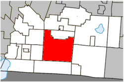
Dunham, Quebec
Dunham | |
|---|---|
 Location within Brome-Missisquoi RCM. | |
| Country | |
| Province | |
| Region | Montérégie |
| RCM | Brome-Missisquoi |
| Constituted | September 25, 1971 |
| Government | |
| • Mayor | Jean Guy Demers |
| • Federal riding | Brome—Missisquoi |
| • Prov. riding | Brome-Missisquoi |
| Area | |
| • Total | 196.20 km2 (75.75 sq mi) |
| • Land | 195.18 km2 (75.36 sq mi) |
| Population (2011)[3] | |
| • Total | 3,471 |
| • Density | 17.8/km2 (46/sq mi) |
| • Pop 2006-2011 | |
| • Dwellings | 1,709 |
| Time zone | UTC−5 (EST) |
| • Summer (DST) | UTC−4 (EDT) |
| Postal code(s) | |
| Area code(s) | 450 and 579 |
| Highways | |
| Website | www |
Dunham is a city in the Canadian province of Quebec, located in Brome-Missisquoi Regional County Municipality. The population as of the Canada 2011 Census was 3,471.
Demographics
Population
Canada census – Dunham, Quebec community profile
| 2011 | |
|---|---|
| Population | 3,471 (+2.2% from 2006) |
| Land area | 195.18 km2 (75.36 sq mi) |
| Population density | 17.8/km2 (46/sq mi) |
| Median age | 46.4 (M: 46.7, F: 46.1) |
| Private dwellings | 1,709 (total) |
| Median household income | $67,068 |
|
|
|
Language
| Canada Census Mother Tongue - Dunham, Quebec[7] | ||||||||||||||||||
|---|---|---|---|---|---|---|---|---|---|---|---|---|---|---|---|---|---|---|
| Census | Total | French
|
English
|
French & English
|
Other
| |||||||||||||
| Year | Responses | Count | Trend | Pop % | Count | Trend | Pop % | Count | Trend | Pop % | Count | Trend | Pop % | |||||
2011
|
3,455
|
2,625 | 75.98% | 695 | 20.12% | 55 | 1.59% | 80 | 2.31% | |||||||||
2006
|
3,365
|
2,505 | 74.44% | 745 | 22.14% | 80 | 2.38% | 35 | 1.04% | |||||||||
2001
|
3,185
|
2,350 | 73.78% | 720 | 22.61% | 55 | 1.73% | 60 | 1.88% | |||||||||
1996
|
3,315
|
2,560 | n/a | 77.22% | 670 | n/a | 20.21% | 35 | n/a | 1.06% | 50 | n/a | 1.51% | |||||
See also
References
- ^ a b Ministère des Affaires municipales, des Régions et de l'Occupation du territoire: Dunham
- ^ Parliament of Canada Federal Riding History: BROME--MISSISQUOI (Quebec)
- ^ a b c 2011 Statistics Canada Census Profile: Dunham, Quebec Cite error: The named reference "cp2011" was defined multiple times with different content (see the help page).
- ^ "Banque de noms de lieux du Québec: Reference number 19766". toponymie.gouv.qc.ca (in French). Commission de toponymie du Québec.
- ^ "2006 Community Profiles". 2006 Canadian Census. Statistics Canada. August 20, 2019.
- ^ "2001 Community Profiles". 2001 Canadian Census. Statistics Canada. July 18, 2021.
- ^ a b Statistics Canada: 1996, 2001, 2006, 2011 census
External links
