
East Homer, New York
East Homer, New York | |
|---|---|
 East Homer, New York  East Homer, New York | |
| Coordinates: 42°39′58″N 76°06′06″W / 42.66611°N 76.10167°W | |
| Country | United States |
| State | New York |
| County | Cortland |
| Elevation | 1,138 ft (347 m) |
| Time zone | UTC-5 (Eastern (EST)) |
| • Summer (DST) | UTC-4 (EDT) |
| ZIP code | 13056 |
| Area code | 607 |
| GNIS feature ID | 949129[1] |
East Homer is a hamlet in Cortland County, New York, United States. The community is located along New York State Route 13 6 miles (9.7 km) northeast of Cortland. East Homer had a post office until June 17, 1995; it still has its own ZIP code, 13056.[2][3]
References
- ^ "East Homer". Geographic Names Information System. United States Geological Survey, United States Department of the Interior.
- ^ United States Postal Service. "USPS - Look Up a ZIP Code". Retrieved September 22, 2017.
- ^ "Postmaster Finder - Post Offices by ZIP Code". United States Postal Service. Retrieved September 22, 2017.
Municipalities and communities of Cortland County, New York, United States | ||
|---|---|---|
| City | 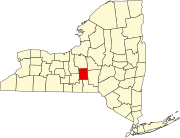 | |
| Towns | ||
| Villages | ||
| CDPs | ||
| Hamlets | ||
This article about a location in Cortland County, New York is a stub. You can help Wikipedia by expanding it. |