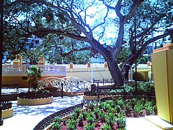
El Parterre
Appearance
El Parterre – Ojo De Agua | |
 | |
| Location | Bounded by Muñoz Rivera, Gonzalo Firpo, José de Diego, and Mangó Streets Aguadilla, Puerto Rico |
|---|---|
| Coordinates | 18°25′55″N 67°09′15″W / 18.432083°N 67.154279°W |
| Built | 1851 |
| Architect | Hau, Enrique |
| NRHP reference No. | 86000781 |
| Added to NRHP | January 13, 1986 |
El Parterre is a landscaped plaza in Aguadilla, Puerto Rico, that was built in 1851. The plaza encloses the Ojo de Agua, a natural spring which was a source of water for Spanish soldiers.[1]
The park and spring were listed on the U.S. National Register of Historic Places in 1986.[2]
See also
References
- ^ Bourdony, José Rafael; Reichard, Herman (July 1984), National Register of Historic Places Inventory — Nomination Form: El Parterre - Ojo de Agua (PDF), retrieved January 14, 2016.
- ^ National Park Service (January 24, 1986), Weekly announcement of National Register of Historic Places actions (PDF), p. 9, retrieved January 14, 2016.
External links


