
Ethridge, Montana
Ethridge, Montana | |
|---|---|
| Country | United States |
| State | Montana |
| County | Toole |
| Elevation | 3,543 ft (1,080 m) |
| Time zone | UTC-7 (Mountain (MST)) |
| • Summer (DST) | UTC-6 (MDT) |
| ZIP code | 59435 |
| Area code | 406 |
| GNIS feature ID | 771247[1] |
Ethridge is an unincorporated community in Toole County, Montana, United States. Ethridge is located on U.S. Route 2 and the Hi-Line 12.6 miles (20.3 km) east-northeast of Shelby. The community has a post office with ZIP code 59435.[2][3]
References
- ^ "Ethridge". Geographic Names Information System. United States Geological Survey, United States Department of the Interior.
- ^ United States Postal Service (2012). "USPS - Look Up a ZIP Code". Retrieved 2012-02-15.
- ^ "Postmaster Finder - Post Offices by ZIP Code". United States Postal Service. Retrieved July 8, 2014.
Municipalities and communities of Toole County, Montana, United States | ||
|---|---|---|
| City | 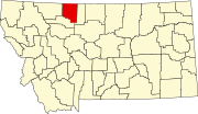 | |
| Towns | ||
| CDPs | ||
| Other communities | ||
This Montana state location article is a stub. You can help Wikipedia by expanding it. |